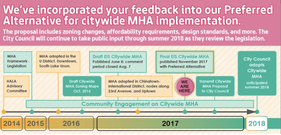
On November 9, the City released its Mandatory Housing Affordability (MHA) Environmental Impact Statement (EIS) that includes proposed changes to zoning in four areas of the Ravenna-Bryant neighborhood. Previous posts provided overviews of proposed changes in the part of the neighborhood closest to the Roosevelt light rail station and about proposed changes to NE 55th Street. This post provides information about proposed changes to the Ravenna NE 65th Street business district and a final one will cover 35th Avenue NE.
What is being proposed on NE 65th Street?
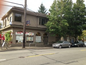
Currently, many buildings on NE 65th Street between 20th Ave NE and 25th Ave NE are not as tall as they could be. For example, this building could be 3-4 stories under current zoning code.
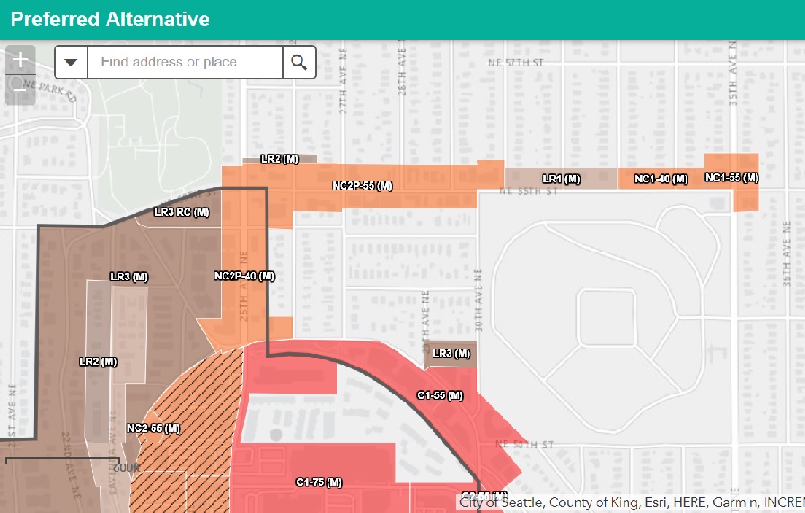
The five block stretch along NE 65th Street from 20th Avenue NE to 25th Avenue NE is often considered “downtown” Ravenna. It is home to many places to eat and drink and health and wellness-related businesses. With a few buildings that include apartments, it is also home to many people.
Most of NE 65th Street in downtown Ravenna is zoned NCP2-40, Neighborhood Commercial Pedestrian up to 40 feet high. Typical land uses in NC2 zones include medium-sized grocery stores, drug stores, coffee shops, customer service offices, medical facilities, and apartments. Non-residential uses typically occupy the front.
In 2015, the area was rezoned a pedestrian area. In pedestrian zones, residential uses may occupy no more than 20% of the street-level, street-facing façade; buildings cannot have large blank facades facing the street; and parking lots on the site cannot be in front of the building or abut the street.
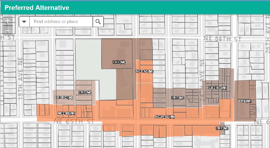
As part of the MHA program, the City’s “preferred alternative” for increasing zoning capacity would change the code for these properties to NC2P-55, increasing allowable height by 15 feet.
In the middle of the block of Ravenna Avenue NE, between NE 65th Street and NE 68th Street and across from the Ravenna-Eckstein Community Center, land that is currently designated NC1-30 would change to NC1-40, increasing allowable height by 10 feet.
Map of proposed zoning changes to NE 65th Street between 20th Avenue NE and 25th Avenue NE from the City of Seattle’s HALA website.
What’s next?
The MHA EIS is now in the hands of the City Council. After considering the EIS and holding public hearings, they will take action in 2018. Amendments to the official zoning map, amendments to the text of the Land Use Code, and changes to maps and policies of the Comprehensive Plan will need to be made.
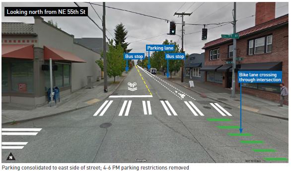
On November 9, the City released its Mandatory Housing Affordability (MHA) Environmental Impact Statement (EIS) that includes proposed changes to zoning in four areas of the Ravenna-Bryant neighborhood. A previous post provided an overview of proposed changes in the part of the neighborhood closest to the Roosevelt light rail station. This post will provide information about proposed changes to NE 55th Street and future posts will cover proposed changes to the Ravenna NE 65th Street business district and to 35th Avenue NE.
What is being proposed on NE 55th Street?
Currently, from 25th Avenue NE to 30th Avenue NE, both sides of the street are zoned for Neighborhood Commercial 2, Pedestrian, 40 feet (NC2P-40). Right now, none of the buildings on this stretch of NE 55th Street are built as tall as they could be and many do not include commercial space. As part of the MHA program, the City is proposing that these properties be zoned NC2P-55, increasing the allowable height by 15 feet.
Typical land uses in NC2 zones include medium-sized grocery stores, drug stores, coffee shops, customer service offices, medical facilities, and apartments. Non-residential uses typically occupy the street front.
Map of proposed zoning changes to NE 55th Street and NE Blakely Street from the City of Seattle’s HALA website.
Between 30th Ave NE and 33rd Ave NE, the land is currently zoned Lowrise 1 (LR1) and no changes are proposed.
From 33rd Ave NE to the alley next to La Villa, properties are currently zone NC1-30 and could be changed to NC1-40, adding 10 feet.
The corner of 35th Ave NE and NE 55th Street is currently zoned NC1-40 and could be changed to NC1-55.
Drawing courtesy of Department of Planning and Development (now the Department of Construction and Inspections.)
In addition to NE 55th Street changes, the map above shows proposed changes along NE Blakeley Street. Land that is now Commercial 1, 40 feet (C1-40) would become C1-55. Commercial areas are not only meant for businesses serving the surrounding neighborhood (like NC zones) but also those serving the wider city and regional clients.
What’s next?
The MHA EIS is now in the hands of the City Council. After considering the EIS and holding public hearings, they will take action in 2018. Amendments to the official zoning map, amendments to the text of the Land Use Code, and changes to maps and policies of the Comprehensive Plan will need to be made.
On November 9, the City released its Mandatory Housing Affordability (MHA) Environmental Impact Statement (EIS) that includes proposed changes to zoning in four areas of the Ravenna-Bryant neighborhood. This post is about proposed changes in the part of the neighborhood closest to the Roosevelt light rail station. Future posts will provide information about proposed changes to NE 55th Street, the Ravenna NE 65th Street business district, and to 35th Avenue NE.
What are MHA and EIS?
MHA is a new policy addressing Seattle’s growth, the need for more housing, and the desire to increase housing and jobs near frequent transit, in line with the City’s urban village strategy. MHA requires new development to either include affordable housing or contribute to a fund for producing affordable housing. In exchange, the City is increasing zoning capacity, allowing for taller buildings. MHA mostly encourages additional housing capacity in urban villages with easy access to transit.
The EIS identifies and describes potential impacts on the environment that could result from changing zoning associated with MHA policy. Environmental impacts were measured for:
After analyzing environmental impacts, the City came up with “preferred” zoning changes. The proposed preferred changes in the area of Ravenna-Bryant closest to the Roosevelt light rail station include expanding the Roosevelt Urban Village boundary from 15th Avenue NE to 17th Avenue NE and changing zoning designations as follows:
At the east corner of NE 65th Street and 15th Avenue NE, increase capacity from Neighborhood Commercial 2, 40 feet (NC2-40) to Neighborhood Commercial 2, 55 feet (NC2-55);
On 15th Ave NE, north of NE 63rd Street and south of NE 68th Street, increase capacity from detached Single Family (SF) to Lowrise 2 (LR2);
On the north side of NE 65th Street west of 17th Ave NE, increase capacity from SF to Lowrise 1 (LR1);
The remaining urban village expansion area would increase capacity from detached SF to Residential Small Lot (RSL).
Map of proposed changes to the Roosevelt Urban Village.
What do these zoning designations mean?
Residential Small Lots: These areas would remain zoned for detached homes and would allow for property owners to build detached homes for multiple single families on one lot. Examples include skinny houses with the front of each house facing the street; “tandem” houses with one facing the street the other behind it; or “cottages” up to 650 square feet each.
Lowrise 1: Provides a transition between SF areas and multifamily and commercial areas. A mix of housing types similar in scale to detached single family homes such as cottages, rowhouses, and townnhouses are encouraged.
Lowrise 2: Allows for a variety of multifamily housing types in existing multifamily neighborhoods and along arterial streets. A mix of small scale to multifamily housing such as townhouses, rowhouses, and apartments are encouraged.
Neighborhood Commercial: A moderately-sized pedestrian-oriented shopping area that provides a full range of retail sales and services to the surrounding neighborhood. Typical land uses in NC2 zones include medium-sized grocery stores, drug stores, coffee shops, customer service offices, medical facilities, and apartments. Non-residential uses typically occupy the street front.
Drawing courtesy of Department of Planning and Development (now the Seattle Department of Construction and Inspections)
What’s next?
The MHA EIS is now in the hands of the City Council. After considering the EIS and holding public hearings, they will take action in 2018. Amendments to the official zoning map, amendments to the text of the Land Use Code, and changes to maps and policies of the Comprehensive Plan will need to be made.
The City’s timeline for implementing the MHA policy.
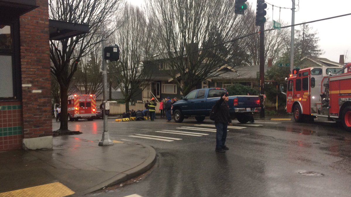
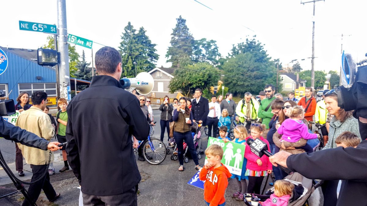
On February 4, 2017, a Saturday afternoon, this was the scene at NE 65th Street and 20th Avenue NE. Doris Van Allen (age 89) was struck by the driver of a pick-up truck as she walked in the crosswalk. She was taken to the hospital with serious head injuries and later died.
On Sunday, neighbors are invited to remember Doris Van Allen and Junhui Wang (age 26), who was struck and killed as she crossed NE 65th Street at Roosevelt Ave NE on January 26, 2017.
WHAT: As part of World Day of Remembrance for Road Traffic Victims, join Councilmember Rob Johnson and neighbors in commemorating the two people killed while crossing NE 65th Street in 2017.
WHERE: Meet at the corner of Roosevelt and NE 65th Street, where a silhouette will be placed in remembrance of Junhui Wang. The group will then walk east on NE 65th Street and place a silhouette on the corner of 20th Avenue NE and NE 65th Street in remembrance of Doris Van Allen.
In 2016, RBCA joined with the Roosevelt Neighborhood Association and NE Seattle Greenways to create the #Fix65th coalition toadvocate for changes to NE 65th Street and to make it safer for all who use it.
Last week the City of Seattle’s Department of Construction and Inspections (SDCI) issued the final recommendation of the Northeast Design Review Board (DRB) for University Village’s (U Village) application for a major phased development. The application covers the construction of many buildings over an extended period of time (up to 15 years). The first phase is constructing a seven-story parking garage fronting 25th Ave NE, which will contain approximately 350,000 square feet of parking. The Northeast DRB’s review recommendation pertains only to the first phase.
RBCA has been tracking this project and attended DRB meetings on December 19, 2016 and September 25, 2017 to provide public comment and submit letters highlighting concerns about connectivity to the surrounding neighborhood, retail on 25th Ave NE, pedestrian and bicycle safety, impacts to traffic, and need for coordination by developers in this general vicinity (see earlier posts with RBCA letters).
The Northeast DRB voted 4-0 to approve U Village’s design for the garage and to proceed with a Master Use Permit application for the project. The DRB noted that improvement have been made to the following areas of design:
Micro-retail added on 25th Ave NE
Pedestrian passageway from 25th Ave NE through the parking garage to the elevator lobby and interior of the Village had been improved
Elimination of one additional lane of traffic into the garage from 25th Ave NE
Better modulation of the north and south façades and more terraced plantings to improve the overall massing.
The Northeast DRB requested SDCI to approve two departures from the Land Use Code: 1) the width of curb cuts (decrease from existing 46 ft to proposed 37 ft) and 2) reduce the depth of ground floor commercial space from required 30 ft minimum to proposed 25 ft depth. The DRB conditioned these departures on U Village complying with the following two conditions:
Installation of interpretive signage related to history of Ravenna Creek along the proposed bioswales along 25th Ave NE; and
Incorporating two or more areas along the building side of 25th Ave NE to allow for wider sidewalks so pedestrians can pass in comfort.
The next step for U Village is to obtain a Master Use Permit for the project to proceed. We will continue to track and monitor the project.
On September 25, the Northeast Design Review Board (DRB) held its second Early Design Guidance (EDG) meeting on the University Village proposed major phased development. The Land Use Application is to allow five new retail buildings and one, seven-story garage building with retail and parking for 880 vehicles (University Village Major Phased Development). Review includes 10,000 sq. ft. of demolition and the removal of 467 surface parking spaces.
The RBCA Land Use committee has engaged the developer and submitted its second comment letter on the project. Two RBCA board members attended the EDG meeting to provide public comments for consideration by the DRB. The comments focused on pedestrian and bicycle safety along 25th Ave NE, and the need for developers in this area along and across 25th Ave NE to work together to make the connections between the neighborhoods and the Burke-Gilman trail safer and easier for pedestrians and cyclists. Below is the letter.
September 25, 2017
Michael Dorcy, Planner
Seattle Department Construction Inspections
Re: Project #3025629 4500 25th Ave NE; University Village West Garage
Mr. Dorcy:
The Ravenna-Bryant community is directly impacted by the proposed project, so we have taken great interest in the latest development proposal by U Village. RBCA submitted comments in December 2016 at the first EDG meeting and now we are submitting new comments about this project, specifically related to the West garage expansion and the impact of traffic on the intersections and circulation of pedestrians, bicycles, and vehicles in the context of the significant development that is proposed on both sides of 25th Ave NE in the next couple of years.
We appreciate that the project design has evolved to address some of the concerns raised in our first comment letter, however we still have concerns relating to the public realm along 25th Ave NE and transportation generally. Further, we greatly appreciate the efforts of the three developers in this area (U Village, Phoenix, and Greystar) to work together to make their developments complement each other and improve the overall circulation and safety for pedestrians, bicyclists and vehicles. This cooperation is imperative given the redevelopment of these blocks will provide a major opportunity to improve pedestrian orientation along 25th Ave NE and create a safer, more functional multi-modal transportation network in the area. While 25th Ave NE is a major arterial, it is also a major pedestrian thoroughfare that has more pedestrians and bicycles using it given the connection to the light rail station less than 1 mile away and the access to the regional Burke-Gilman trail.
We list below the following bullet points to summarize our concerns:
Pedestrian safety on 25th Ave NE: We have three major concerns about pedestrian access and safety:
Garage Ingress/Egress: The DRB Recommendation Packet seems to reflect three travel lanes, including only one left-turn lane onto southbound 25th Ave NE. This is different from the four-lane option in the EDG package. We support SDOT’s position that a four-lane configuration would compromise pedestrian safety at the 47th Street intersection.
49th Street Intersection: The garage entrance will eliminate one of two east-west through-connections that exist today across U Village. The remaining one, 49th Street, already seems like a dangerous access point, as 49th is an off-set intersection and there are three sets of adjacent curb cuts along the east side of 25th (U Village, Office Depot and Jiffy Lube), which present a safety hazard, in our opinion. As more cars seek to make an unprotected left into U Village, either to drop off/pick up passengers, access other garages on site, or fruitlessly search for surface parking, the additional turns will exacerbate the already challenging conditions. This potential diversion of left-hand turns to this intersection does not seem to be assumed in the Transpo report.
Pedestrian experience on 25th Ave NE: We appreciate the micro-retail, which is a modest but appreciated improvement from the EDG design. We have met with U Village and understand their programmatic and economic challenges with more providing more active street-front uses along 25th Avenue NE. However, there still will be a stretch of more than 200 linear feet from the micro-retail to 49th Street NE without any active uses. Even with the nicely appointed landscapes depicted in the design packet, the combination of arterial traffic and inactivity along the property will make for a challenging pedestrian environment. We encourage U Village to consider how to provide lighting to enhance real and perceived pedestrian safety, and to consider widening the sidewalk to allow for two parties to pass comfortably in light of the lack of eyes on the street in this location.
Cumulative traffic impacts from development proposed in this same vicinity: In addition to the U Village West garage, there are two other proposals going through the EDG phase: 1) Greystar (Project #3027063) and 2) Phoenix Trailside (Project #3027312) projects. The Greystar project proposes 205 units and 140 parking stalls and the Phoenix project proposes 293 units with 286 parking stalls. Both developments are seeking rezones from C-40 to NC2 65 or 75 and LR3 to NC2-85, respectively. We think density done well is welcome in an urban village with as many amenities as our Ravenna Bryant neighborhood and we welcome the additional housing options. However, these are big changes for this area and it will significantly increase the volumes of people and traffic who need to move around safely. According to the transportation study shown on Table 3, the future LOS for 13 of the 20 intersections will be at D, E or F by 2027. Currently the existing baseline shows nine intersections operating at D, E or F at this time. Anyone driving during commute hours AM or PM peak knows that 25th Ave NE is a parking lot and traffic moves to a crawl. We are concerned that the additional approximately 311 net new trips during the weekday PM peak hour created by the new garage only adds additional stress. This does not even account for the increased traffic that the Greystar proposal (Project #3027063) and Phoenix’s Trailside proposal (Project #3027312) will add to the traffic on intersections and on 25th Ave NE.
Bicycle Connection along 47th: In part due to the Phoenix project’s pursuit of a street vacation, there is a plan for a bicycle and pedestrian connection that would run from the Burke Gilman Trail to 25th Ave NE along 47th Unfortunately, 47th is offset from the traffic light at the planned garage entrance, creating potential dual crossing of 47th and then 25th Ave NE to reach U Village from the Burke Gilman Trail. We encourage U Village to continue coordinating with Phoenix and Greystar to devise a plan, in conjunction with SDOT, that can meet the U Village’s vehicular access needs while supporting a seamless bicycle and pedestrian connection.
Thank you for considering our comments as you complete your review of University Village’s proposal and please let me know if we can answer any questions or participate in any manner as the process moves forward.
Over the past several years, plans have been developed with the goal of creating a safe and pedestrian-friendly experience for neighbors wishing to walk to businesses and services on 35th Avenue NE from NE 55th Street to NE 85th Street.
Future of 35th Avenue NE Plan
Planning for the future of 35th Avenue NE public workshop circa 2014. Photo courtesy of Future of 35th Ave NE blog.
Between 2012 and 2015, the Ravenna-Bryant Community Association, the Wedgwood Community Council, and neighbors from both communities worked together to develop a plan, including design guidelines, for creating a vibrant 35th Avenue NE.
Pedestrian safety improvements along arterial roads
While the RBCA board has focused most of our mobility-related advocacy efforts on improving safety along the NE 65th Street corridor most recently, all arterial roads in the neighborhood have been identified as needing changes to make them safer for all who use them.
In a 2016 survey about neighborhood mobility concerns, pedestrian safety was the primary concern. The most common complaint regarding pedestrian safety, as well as motorist and biker safety, was people speeding in their cars along both arterial and residential streets. The second most common complaint was about how difficult it is to cross arterial roads and, interestingly enough, it wasn’t only pedestrians and bikers who identified this as a big problem. Motorists thought it was a problem, too. Reducing the number of speeding cars on arterial roads, like 35th Avenue NE, is one of RBCA’s priorities in our 2017 mobility safety action plan.
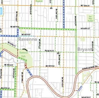
Seattle Bike Master Plan
Bike Master Plan in Ravenna-Bryant
The Seattle Bike Master Plan (BMP) was adopted in 2014 and includes changes to 35th Avenue NE. The BMP provides a blueprint for increasing safety features for people who use bicycles to get around the city, including NE Seattle.
On 35th Avenue NE, sharrows (shown as yellow dotted lines in the map to the left) are planned from NE 45th Street to NE 65th Street. From NE 65th Street to NE 75th Street on 35th Avenue NE protected bike lanes (blue line) are included in the plan.
In addition to increasing safety for bikers, bike lanes can reduce the speed at which cars travel and, therefore, increase safety for all who use the road, including motorists.
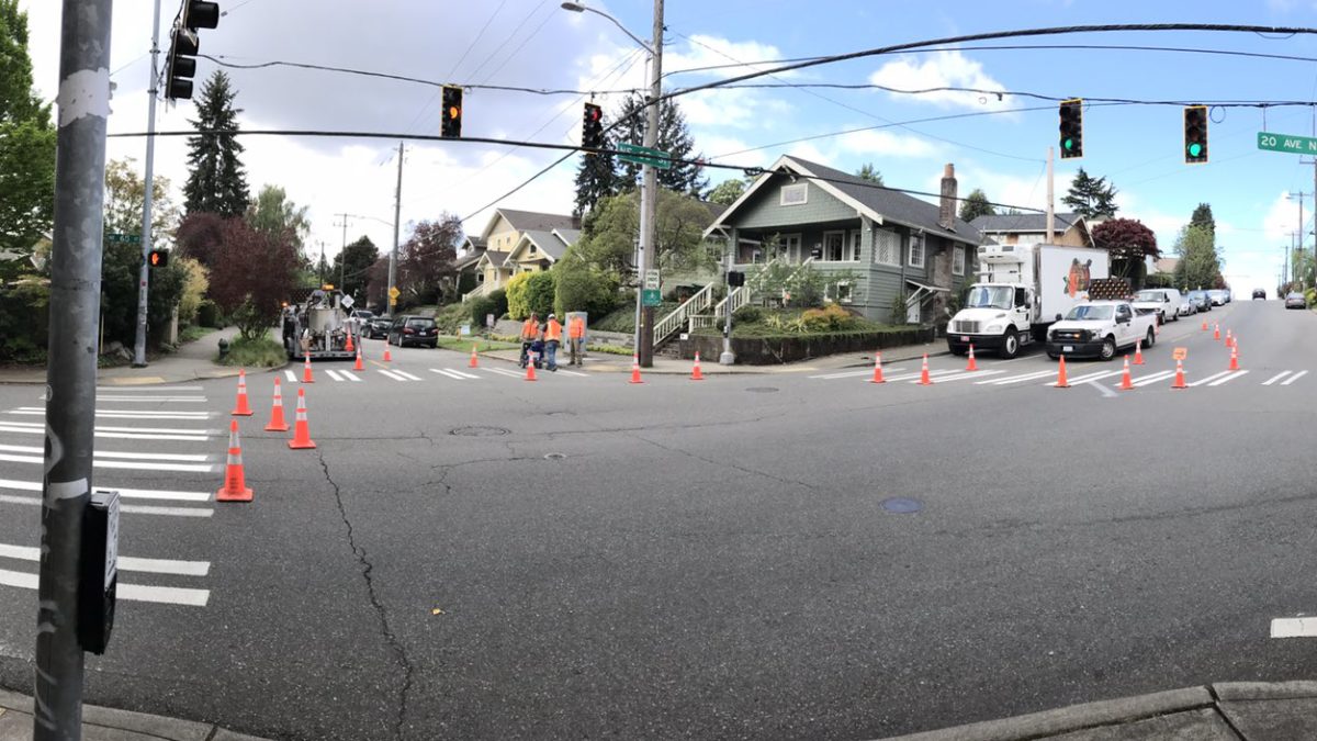
SDOT paving project
In NE Seattle, 35th Avenue NE is one of streets scheduled for re-paving. According to the Seattle Department of Transportation (SDOT), paving is an opportunity to cost-effectively update street designs to promote safety, build features called for in citywide transportation plans (like the BMP), and coordinate with other projects. As part of the 35th Avenue NE paving project, SDOT is taking the opportunity to make planned changes all at once, instead of in a piecemeal manner. The project includes re-paving most of the road, adding safety improvements, and improving reliability for transit users. Detailed information about the paving project is available online.
SDOT open house
On October 21, starting at 10:00 a.m. at the Messiah Lutheran Church, 7050 35th Ave NE, SDOT will host an open house for neighbors to learn more about the paving project.
SDOT’s conceptual view of changes to be made looking north from the corner of 35th Avenue NE and NE 55th Street.
The meeting will begin with an open house during which attendees will be able to review project boards and ask one-on-one questions. From 11:30 a.m.-12:30 p.m. those who would like to go on a walking tour will break up into groups and visit either NE 75th St & 35th Ave NE or NE 65th St & 35th Ave NE.
Community members are encouraged to learn more about plans that will guide changes to the 35th Avenue NE corridor within the not-so-distant future. As the population of our city continues to grow, the way people get around the neighborhood is going to change. Now is the time to become familiar with what is planned, think about how the implementation of those plans will change neighborhood mobility safety, and ensure that what is created is sustainable, supports a livable and vibrant community, and meets the needs of a diverse population.
The Ravenna-Bryant Community Association board of directors will meet next week. All RBCA meetings are open to anyone interested in participating. Neighbors are encouraged to attend!
RBCA Board Meeting
Tuesday, October 3, 2017, 6:30-8:30 p.m.
Ravenna-Eckstein Community Center
AGENDA
1. Welcome & Introductions
2. Ravenna/Cowen Park
Encampments
Drafted letter re: response to opioid crisis
3. Executive Committee Reports
Secretary’s Report
Treasurer’s Report
President’s Report
Old business: Draft e-vote process
Old business: Better Know A Board Member
Old business: Membership Chair vacancy
New business: Vote – New RBCA CUCAC representative
A Design Review Board meeting about the proposed 7-story University Village garage on 25th Avenue NE is scheduled for Monday, September 25, 8:00 p.m. at the Good Shepherd Center in Wallingford.
Here are some of the drawings of the latest design proposal from a pedestrian’s point of view.
Drawing of proposed University Village west garage. The people in this image are walking in front of the Office Depot driveway.Walking south on 25th Avenue NE along the proposed University Village west garage.Street view of bus stop, micro retail, and pedestrian entrance to the proposed University Village west garage.Pedestrian passageway from 25th Ave NE through the proposed University Village west garage.Car, bike, and pedestrian entrances to University Village at the south end of the proposed west garage. (That’s Restoration Hardware on the right.)
All documents related to the proposed garage are available online under project 3025629. Comments about the garage design may be sent to the Design Review Board at PRC@seattle.gov.
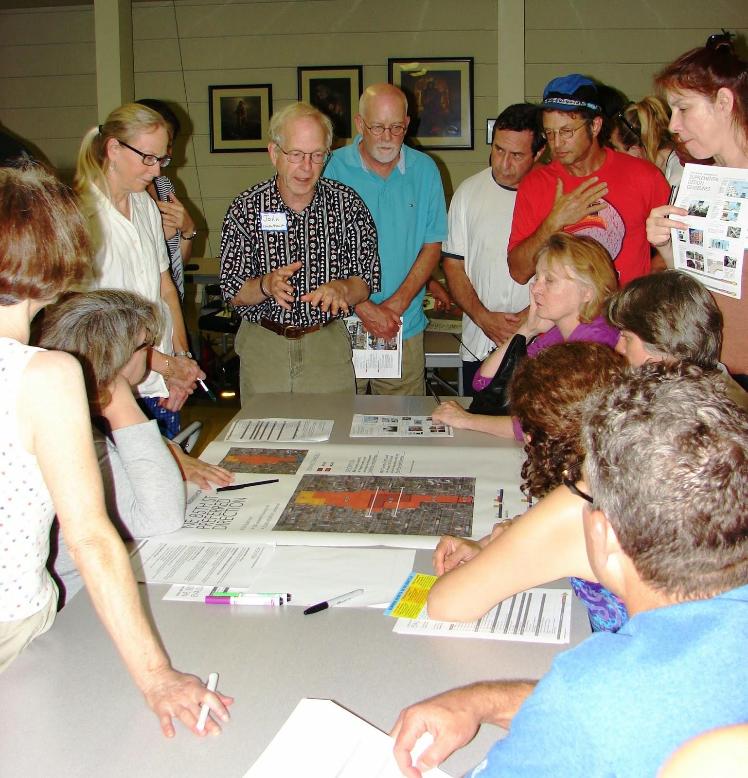
A group of Ravenna neighbors participated in the July 11, 2017 RBCA board meeting and shared their comments about the Mandatory Housing Affordability (MHA) Draft Environmental Impact Statement (DEIS). In addition to requesting that the RBCA board include their comments in any communication they may have with the City regarding the DEIS, it was requested that their comments be posted to the RBCA website.
Below are their drafted comments which include a suggested alternative to zoning changes proposed in the DEIS. Thoughts about the proposal below may be left after the post. (Please note that the comments section is moderated and new comments may not immediately appear, especially if moderators are on vacation.)
To: Office of Planning and Community Development
Re: Comments to the MHA DEIS issued by the city of Seattle on June 8, 2017
We support Seattle’s effort to increase affordable housing and supports the MHA inclusionary zoning policy, the subject of the DEIS. In addition, since we support efforts to make Seattle more equitable, not just the Urban Villages, we request an Alternative 4 described herein be included in the Action Alternatives.
We strongly support requiring MHA developers in areas designated “high opportunity” to be required to include affordable units in their developments, rather than contribute a fee, as this policy will more directly ensure that affordable units are distributed equitably in the City, and minimize displacement.
Alternative 4, Part One: Where appropriate, do transitions outside of Urban Villages, implement appropriate zoning within the adjacent SF neighborhood, rather than move the Urban Village Boundary or Expand the Urban Village
We affirm much of the increased zoning proposed in OPCD’s October 2017 Plan, and parts of Alternatives 2 and 3 of the DEIS, as clarified below. In exchange for the new zoning, and in response to neighborhood concerns, and adverse impacts identified in the DEIS, we believe the MHA program goals can be better accomplished by creating a more effective transition between the Roosevelt Urban Village and Ravenna outside of the Urban Village, while keeping the Roosevelt Urban Village eastern boundary along the current border of 15th Ave NE and not expanding the Urban Village to the east.
Alternative 4, Part Two: Allocate Planning Resources to SF neighborhoods who want to plan proactively for expansion of housing opportunities in their neighborhoods
We propose to study options for increasing housing opportunities in the broader community of Ravenna/Bryant. This policy would reward neighborhoods who want to plan proactively, could extend the reach of the MHA; create more walkable neighborhood business districts; more family-size, ground related, mixed-income housing in the neighborhood.
Summary of support for proposed zoning changes and clarifications: The attached map provides an overview of zoning changes we are proposing east of 15th Avenue NE where the Ravenna and Roosevelt neighborhoods meet.
North of NE 65th:
Adopt OPCD’s proposed rezoning from SF to LR3 along the East side of 15th Ave NE from NE 65th to NE 68th St. (same as OPCD Plan & Alternative 3, higher than Alternative 2). Our design preference would be row houses with backyards to provide more room for the tree canopy and storm water retention, and create a better buffer for lower zoning to the east.
Adopt modified proposed new zoning from SF to LR-1 along the West side of 16th Ave NE from NE 65th to NE 68th. (change from OPCD & Alt 3 LR -2, but higher than Alt. 2)
Change RSL to SF from the East side of NE 16th Ave to the West side of NE 17th (including the commercial on NE 65th except for the existing NC-40 on 15th Ave NE. )*
South of NE 65th–
Keep Existing NC-40-55 south of NE 65th St along from 15th Ave. NE (same as all options)
Retain SF south of existing NC-40-55 zoning as SF along 16th Ave NE and 15th Ave NE.
*Change all RSL to SF because current policy restricts RSL to Urban Villages
Map showing zoning changes proposed by neighbors in response to MHA DEIS.
Description of Impacts, Mitigation, and Comparisons of Action Alternatives
The proposed changes pertain to local conditions that will result in better, more gradual transitions between MF and SF and will mitigate concerns about land use impacts of bulk and scale, shade, and solar access. Not changing the Boundary will also mitigate impacts to historical resources; aesthetics, transportation & parking, as well as better protect the tree canopy, Ravenna Ravine and Creek and improve storm water management. Concurrently accepting many of the proposed changes in zoning will provide increases in density, promote needed redevelopment of 15th Ave NE and create new opportunities for MHA affordable units. The local impacts and mitigations are described below as well as a comparison of the Action Alternatives.
The current boundary of 15th Ave NE makes better sense than 16th or 17th Ave NE. The proposed expansion area of the Roosevelt Urban Village is relatively small just one or two blocks east, except for a small sliver in Alternative 3 along the main arterial NE 65th from 16th Ave NE to 20th Ave NE. Boundaries normally are articulated on arterials, not on narrow residential streets, such as 16th or 17th Ave NE. In the case of the Roosevelt Urban Village, better, more legible, gradual transitions between urban village densities and SF can be created outside of the urban village, rather than changing the boundary.
The proposed zoning provides a better transition from urban form to SF. The zoning is identical to Alternative 3 in the step down from the Urban Village on west side of 15th Ave, north of 65th where a new 7 story building is being permitted next to Roosevelt High School, to L-3 on the East side of 15th . We then propose to L-1 on the West side of 16th. LR-1 makes a better transition in bulk and scale than LR2 to SF owners who choose to remain in the LR-1 zone on 16th, and to the SF across the street on the east side of 16th Ave NE. Accepting the up-zones preserves the same potential for MHA affordable units and density on 15th, and slightly less on 16th than Alternative 3, but provides significantly more on both streets than Alternative 2 or Alternative 1. North of 65th is closer to the light rail station and school than the area south of 65th, where the heights across the street in the urban village are lower. The northern end of the West side of 16th is buffered from the LR3 zone by a joint access alley.The houses on the southern end of 16th are already facing a transition to NC40, a remnant of the older zoning preference in Seattle of putting most MF on arterials. Additionally, south of 65th, the proposed expansion of NC-40(55) from SF is too stark a transition and the group has proposed keeping it as single family.
Alternative 2, which proposes RSL on 15th and 16th, would be more compatible in height and bulk to SF, but not necessarily compatible with the established architectural and urban form, and would not produce as many MHA affordable units. The difference between SF, if the boundary remained at 15th under the Sub-Alternative, and the proposed RSL in the Expansion proposed under Alternative 2 or 3 would not be significant. Many of the lots in the area are either too small to support an additional house, or because of the placement of the house on the lot, would require tearing down the existing house and many houses would likely be too expensive and/or sufficiently upgraded to meet current code, energy, seismic, and technology standards to be feasibly redeveloped as RSL within the 20-year framework of EIS analysis. This area already has ADU’s in the area, a more likely scenario to create affordable housing in this area.
Proposed increased zoning on NE 65th St needs further study. Alternative 3 proposes expansion along NE 65th to 20th. This area of 65th is topographically challenged as there is a steep slope up the hill from 16th Ave NE to the crest of the hill at 18th, and then an even steeper descent to 20th. There are no alleys serving the north side of NE 65th, both of these factors are noted in the DEIS to potentially be mitigated by adopting less intensive use. (3.121). This idea currently has some interest in the community but needs further study.
Community Planning recommended by DEIS as mitigation for land use impacts. The DEIS specifically mentions that the current criteria for land use rezones may not be met in Roosevelt (p. 3.118), and that mitigation measures might include, “address potential land use impacts as part of neighborhood level planning efforts.” (p. 3.120) Currently, only areas in Urban Villages have access to city planning resources, and the Alternative Part Two would help areas like Ravenna/Bryant do local level planning.
Neighborhood Design Guidelines Recommended by DEIS
Historic Ravenna, which includes parts of Bryant, has a consistent, established architectural urban form, and is one of Seattle’s well-preserved “bungalow” neighborhoods. Since many homes in Ravenna/Bryant are historic Craftsmen houses, concerns for historical resources and aesthetics have been expressed by neighbors, impacts which have also been identified in the DEIS. One mitigation measure suggested in the DEIS is Neighborhood Design Guidelines, which Ravenna/Bryant does not currently have. (3.165) This is another potential benefit to having neighborhoods do proactive planning.
Alternative 3 expansion along NE 65th to 20th Ave NE needs further study. As mentioned before, there is some interest in the community; specifically to expand LR1, 1 block north and south along NE 65th from 16th Ave NE to 20 Ave NE. The goal is to promote more rapid redevelopment by creating development pathways that work for single lots because in the current intense real estate market for single family houses waiting for two or more adjacent lots to be assembled could stall development. NE 65th is the most logical walking corridor to the light rail station and could connect the business districts of Ravenna and Roosevelt.
Before embracing this idea, more study is needed because of current neighborhood safety concerns about this particular stretch of NE 65th that may or may not be addressed by SDOT’s NE 65th Street Vision Zero Project.
Parking is also a concern of many neighbors. The residential streets are very narrow, and many of the old houses do not have garages, so there is already crowded street parking. This is especially intense on 16th, which has parking on only one side of the street and is often used by students going to Roosevelt. Not moving the boundary of the Roosevelt Urban village will provide parking for the incoming residents, mitigating the impact of the new development.
Historical Resources: Ravenna is one of the older neighborhoods in Seattle, resulting in a treasured collection of historic, architecturally significant Craftsmen and Tudor houses, with some Mid-Century homes. The area has not yet been surveyed and therefore potentially historical resources would be lost as development occurs. The DEIS describes “potential decreases to the historic fabric of a neighborhood” when historic buildings are redeveloped or demolished and new buildings are constructed “that are not architecturally sympathetic to the existing historic characteristics of a neighborhood.” (3.252) Since there is significant, but not universal, concern in the neighborhood about this issue, it is another reason to not extend the boundary of the urban village before the opportunity is lost to preserve what is most important.
Biological Resources Tree Canopy and Environmentally Critical Areas (ECA)
Seattle’s urban forest, mostly located in Seattle’s SF zones, provides many ecological services such as relief from the urban heat island, cleaning our air and water, and helping with storm water management, as well as being described in the DEIS as “fundamental to the character of Seattle.” All Action Alternatives will result in loss of the tree canopy according to the DEIS. Indirect impacts are identified as “changes to stream flows from upstream development” (3.263); cumulative effects of multiple parties actions could potentially alter drainage patterns and/or affect soil and slope stability, and discharges to streams may be impacted by runoff of pollutants from street surfaces. (3.265) Cumulative effects are critical in evaluating future impacts, one construction project may be nothing, many may mean disaster.
Per the pattern of the Programmatic DEIS, these impacts are characterized as not significant city wide because of the relative small amount of acreage. (3.2700) No study specific to the impacts to the Ravenna Park riparian corridor and steep slopes is cited though there have already been problems of erosion and sink holes adjacent to the park. Ravenna Creek is a bit of an anomaly because its original source of water from Green Lake was cut off and diverted to sewer pipes when the Olmstead Brothers created Green Lake Park, thus leaving very local water table sources to provide the flow of the creek.
On a city wide basis, the pattern of growth also needs to be assessed as to whether buffers of SF areas with tree canopy are needed between urban densities that take account of the watersheds as well as just counting acreage. There is no study cited that looks at the future green infrastructure map in comparison with the projections for increasing urban densities and what appropriate policy would integrate them. It is assumed that the Urban Tree Plan protections will suffice, but a new Tree plan is under development to patch recognized deficiencies. The area to the south of 65 Ave NE nearest to the Park is especially important to protect trees to better protect the source of the flow, and to help with storm water management from the city streets.
Ravenna/Bryant has a combined sewer and storm water system which contributes to the CSO overflows and limits the capacity of West Point Sewage treatment plant to function in the new normal of heavier rain storms due to climate change. The city has spent millions of dollars on concrete holding tanks as solutions to this problem, rather than adopting much cheaper Low Impact development methods.
The RBCA board is currently considering these comments and the alternative zoning proposal as part of their review of the MHA DEIS.
The Comprehensive Plan includes an Urban Village Strategy that promotes growth in areas that have places for people to work, live, shop, and access services in close proximity to one another. According to the plan, “Locating more residents, jobs, stores and services in close proximity can reduce the reliance on cars for shopping and other daily trips and decrease the amount of fossil fuels burned and the amount of greenhouse gases emitted. Increasing residential and employment densities in key locations makes transit and other public services convenient for more people and therefore makes these services more efficient.”
Housing Affordability and Livability Agenda
As part of the Housing Affordability and Livability Agenda (HALA), in 2016 the Mayor unveiled the Mandatory Housing Affordability (MHA) proposal that requires that new multifamily residential development contribute to affordable housing, either with affordable homes in the building or payments to help construct them throughout the city. The MHA framework was adopted a year ago for residential development and, to implement that framework, proposals for rezoning parts of neighborhoods throughout the city are currently being considered. Much, but not all, of the rezones are being proposed in urban villages and urban centers.
In December, the Roosevelt Neighborhood Association (RNA) and the Department of Neighborhoods hosted public meetings that provided information and solicited public input about the proposed rezone of the Roosevelt Urban Village, including a proposed expansion of the Urban Village boundary east of 15th Avenue NE into the Ravenna neighborhood.
Environmental Impact Statement
Last month, a draft Environmental Impact Statement (EIS) about possible MHA changes was released. The EIS includes updated proposals for zoning changes, including proposals for expanding the Roosevelt Urban Village into the Ravenna neighborhood. For each neighborhood, three proposals are made:
Alternative 1 – no changes to zoning;
Alternative 2 – implementing MHA based on original planning concepts included in the Comprehensive Plan and the MHA framework.
Alternative 3 – implementing MHA and specifically considering displacement risks and access to opportunities in each neighborhood.
Growth & Equity Analysis
Seattle has a long history of being a segregated city. Thanks in large part to redlining activities by financial, insurance, and other companies, as well as neighborhood covenants, many neighborhoods, including Ravenna-Bryant, excluded African Americans and other people of color from living in them. To decrease segregation throughout the city, the EIS includes an equity analysis to help inform decisions about land use policy changes.
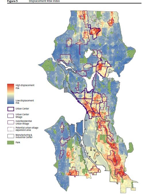
As part of the EIS, the City assessed in which neighborhoods marginalized residents can attain resources, opportunities, and outcomes that improve quality of life and enable them to reach their full potential. Displacement was one outcome of growth that was assessed. Most of Ravenna-Bryant was identified as being at low risk of displacement.
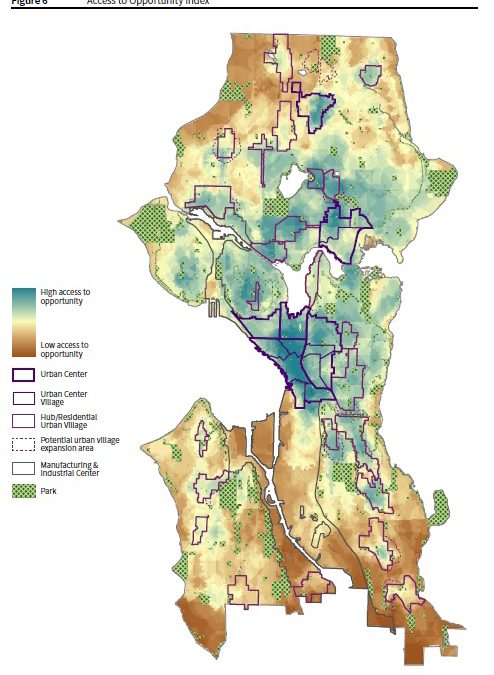
The EIS also included an assessment of access to opportunity within neighborhoods. Access to opportunity includes measures related to education, transit, economic opportunity, civic infrastructure, and public health. Ravenna-Bryant has a great deal of opportunity accessible to those who live and work here.
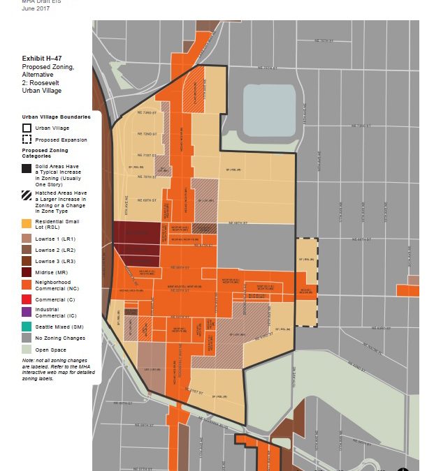
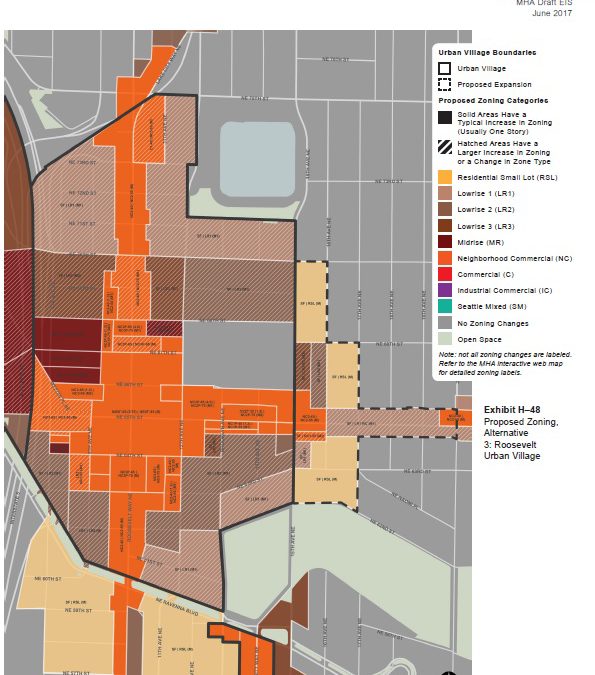
Maps outlining proposed zoning changes in Alternatives 2 and 3 were released with the EIS. Below are the maps for proposed Roosevelt Urban Village changes including changes in the Ravenna neighborhood.
This alternative proposes expanding the Roosevelt Urban Village east to 16th Avenue NE north of NE 63rd Street and south of NE 68th Street. Land that is currently zoned Singe Family (SF) would be rezoned to Residential Small Lot (RSL) and Neighborhood Commercial 2-40 (NC2-40) zones would become NC2-55 zones, increasing allowable building heights by 15 feet.
Alternative 3 in Ravenna
Since Ravenna is considered a neighborhood with low displacement risk and with high access to opportunity, Alternative 3 proposes additional housing capacity changes. Zoning changes on 16th Avenue NE would extend north to 70th Avenue NE and south to NE 62nd Street. A variety of zoning designations are proposed including Lowrise 1, Lowrise, 2, Lowrise 3, and additional NC2-55. Zoning along 17th Avenue NE would change south of NE 68th Street from SF to RSL. Zoning designations along NE 65th Street between the Roosevelt neighborhood and the Ravenna business district would change from SF to Lowrise 1.
What’s next?
The City extended the public comment period to August 7th for the MHA draft EIS. Below are more helpful links to information provided by the City regarding this new policy:
Draft EIS Summary ChapterThis summarizes the findings for each topic in the EIS, such as Housing, Land Use, Aesthetics, and Transportation, among others. At 37 pages, it’s a good way to read an overview of the analysis and discussion of impacts contained in the full Draft EIS.
June 29 Public Hearing boards A public hearing was held on June 29 at City Hall where the public could make comment on the Draft EIS. These boards explain what is in the Draft EIS and some of its key findings.
The RBCA Land Use Committee is hosting a public meeting Thursday to preview several development proposals along 25th Ave NE at U Village and Travelodge sites. Specifically, you will hear from University Village, Greystar (developer for the Travelodge site), and Phoenix (developer for a new residential project behind the Travelodge site.) The goal of the meeting is to provide community members with a holistic view of proposed development slated for 25th Ave NE on these several blocks. We would like to hear from the community, so come give your feedback at the meeting or leave a comment after this post and learn about the changes happening in our neighborhood.
A year ago, neighbors marched along NE 65th Street in the Ravenna and Roosevelt neighborhoods to increase awareness about the many pedestrians, bikers, and motorists who had been sent to the hospital after being involved in collisions on NE 65th Street. The march launched the #Fix65th campaign started by the Ravenna-Bryant Community Association (RBCA), Roosevelt Neighborhood Association (RNA), and NE Seattle Greenways.
June 16, 2016 at the corner of NE 65th Street and 15th Avenue NE. Photo thanks to the Roosevelt Neighborhood Association @roosieseattle
Since then, two pedestrians were killed while crossing in marked crosswalks on NE 65th Street, one in the Ravenna neighborhood and one in the Roosevelt neighborhood.
Since then, the Seattle Department of Transportation launched a NE 65th Street Vision Zero project that included two community forums and some short-term improvements to the road. Plans are being made for further improvements in 2019.
However, RBCA continues to be concerned about the safety of our neighbors who walk, bike, and drive on NE 65th Street. While the short-term improvements are certainly welcome, RBCA is concerned that more people will be seriously injured and killed before large-scale improvements are made.
Today, in partnership with RNA, RBCA sent a letter to City officials in follow-up to the letter sent last July:
June 16, 2017
Dear Mayor Murray and Councilmembers Johnson and O’Brien,
In July of 2016 the Ravenna Bryant Community Association and Roosevelt Neighborhood Association sent a letter expressing our neighborhoods significant safety concerns regarding NE 65th Street and requesting a study of the corridor. We outlined specific issues that needed to be addressed as follows:
Excessive speeding and a lack of enforcement
Insufficient number of safe crossings
Long waits for walk signals
Driving lane orientation
Dangerous intersections
Unsafe sidewalks
Unsafe bicycle infrastructure
Insufficient parking
In response, SDOT committed to fixes that would come in two stages, with quick, short-term fixes happening in 2017. More comprehensive improvements would occur in 2019. The 2017 changes, which are now complete, involved repainting crosswalks, making traffic signals larger, adding flex posts at 65th and Roosevelt, and reducing the speed limit to 25 mph in the Roosevelt business district. But other than the flex posts, we consider this work to be essential maintenance on aging infrastructure.
Increased density along NE 65th Street is not going to wait for 2019. Seattle In Progress shows at least 650 new housing units being built adjacent to 65th, and approximately 1,000 more units pending approval. Most of those buildings include retail and a limited number of parking spaces. The next two years will see dramatically increasing numbers of residents and visitors traveling the corridor by foot, bike, bus, and car.
In the year since we submitted the above referenced letter, two people have died and two more have suffered life-threatening injuries. All of these tragedies have occurred at intersections over a one mile stretch of NE 65th Street and yet there are no further safety improvements planned for two more years. SDOT’s Community Forum on May 18th did not even include potential safety treatments at intersections or future crosswalks, two of the neighborhood’s greatest concerns as determined in surveys by RBCA and SDOT alike.
The short-term fixes are inadequate and fail to address the most dangerous aspects of NE 65th Street. We are painfully aware of what two years can mean for members of our community and are not willing to accept what has been done as an adequate response to a persistent danger to our community. We formally request that the scope of completed work be reviewed and further short-term treatments be developed to address intersections and crossings before the end of July with follow-up work to be completed before the end of the summer.
The Northeast District Council (NEDC) invites you to meet candidates running for Seattle Mayor at 7:00 p.m. Thursday, June 8, 2017 at Wedgwood Presbyterian Church located at the corner of 35th Avenue NE and NE 80th Street.
Candidates participating include:
Jenny Durkan
Jessyn Farrell
Bob Hasegawa
Michael McGinn
Cary Moon
Nikkita Oliver
The event timeline:
7-8:00 p.m. Candidates introduce themselves and address the question of how they will serve Seattle’s diversity of citizens: age group; neighborhood; income; ethnic background, etc.
With two pedestrians killed by motor vehicles within the last nine months, and countless near misses, it’s beyond time to create a safer transportation corridor for all and #Fix65th.
In response to community concerns and advocacy, the Seattle Department of Transportation (SDOT) launched the NE 65th Street Vision Zero Project and, within the last few weeks, they made some quick improvements to make the roadway safer.
NE 65th Street & 20th Avenue NE crosswalks were re-painted May 6. In February, an 80 year-old pedestrian was struck and killed by a motor vehicle here. Photo courtesy of Oralea Howard via Twitter.
Re-painted Crosswalks: On Saturday, SDOT repainted crosswalks on NE 65th Street at 15th, 20th, and 25th Avenues NE. Though every corner is a crosswalk, whether marked with paint or not, painted crosswalks remind drivers that pedestrians have the right of way and to look out for people crossing the street.
Graphic courtesy of SDOT: http://sdotblog.seattle.gov/2016/11/07/your-new-vision-zero-speed-limits/
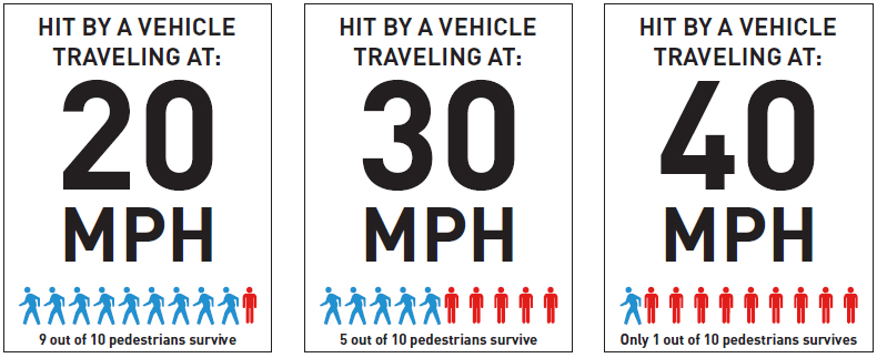
Speed Limit Reductions: SDOT decreased the speed limit to 25 miles per hour between 8th and 12th Avenues NE on NE 65th Street. Higher vehicle speeds are strongly associated with both a greater likelihood of pedestrian crash occurrence and more serious resulting pedestrian injury.
Signal Improvements: Bigger traffic signals with reflective backing were installed to improve visibility, especially at night. Pedestrian countdown timers were added so that all pedestrian signals between NE Ravenna Boulevard and 39th Avenue NE now have them.
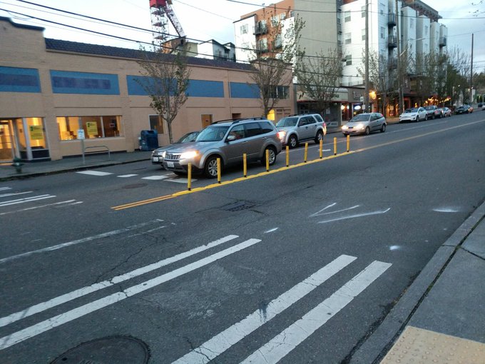
Flexible posts recently installed at NE 65th Street & Roosevelt Way NE. Last September, a pedestrian was struck and killed by a motor vehicle here. Photo courtesy of Dongho Chang via Twitter.
Flexible Posts: On NE 65th Street where it intersects with Roosevelt Way, flexible posts separating the east and westbound lanes were installed. The posts reduce speed and angle for motor vehicles turning from southbound Roosevelt Way to eastbound NE 65th Street. The posts prevent drivers from cutting the corner, improving driver visibility of pedestrians in the crosswalk.
More Changes in 2018: To further increase safety along this busy corridor, more changes are in the works. Learn about possible future road design improvements during the May 18 community forum at Roosevelt High School. Drop in anytime between 6-7:30 p.m., view a variety of proposed changes, and have questions answered by SDOT staff.
The recently redeveloped University Village shopping center generates a significant amount of vehicular traffic in close proximity to the Burke-Gilman Trail . . . University Village is surrounded by single-family residential neighborhoods, whose residents are concerned with through traffic and pedestrian safety. Providing safer facilities for each of these transportation modes requires a combination of improvements to the following problem areas:
Crossing conflicts between bicyclists/pedestrians and vehicles on the Burke-Gilman Trail at 25th Avenue NE and 30th Avenue NE.
Inadequate sidewalks and pedestrian facilities north and east of University Village on . . . NE 50th Street from 30th to 35th Avenues NE.
Why is this relevant today, 15 years later? Because despite mitigation funds from University Village that they requested be used for sidewalks on NE 50th Street, despite two Neighborhood Street Fund applications submitted by RBCA for the project, despite studies conducted by SDOT, and despite ongoing advocacy by RBCA members, the neighborhood is still waiting for sidewalks.
In 2016, SDOT conducted a traffic study and among the findings were that almost 2,000 vehicles use the road per day, which is considered high for a non-arterial street, and that about 50% of drivers on the road exceed the speed limit. This did not come as a surprise to neighbors considering NE 50th Street links the University Village area with the Bryant neighborhood and 35th Avenue NE. Many Bryant community members use the street when walking to businesses and to access the Burke-Gilman Trail.
Most recently, it came to RBCA’s attention that the sidewalk funds from University Village were to be diverted to another SDOT project. Upon learning this, RBCA representatives promptly requested a meeting with SDOT and, in follow-up to that meeting, RBCA sent the following letter.
May 8, 2017
Ms. Sara Zora
Seattle Department of Transportation
700 Fifth Avenue, Suite 3900
Seattle, WA98124-4996
RE: UATAS Project #31 (Sidewalks on NE 50th Street) and Omission in Pedestrian Master Plan
Dear Ms. Zora,
Thank you for meeting with our representatives from the Ravenna-Bryant Community Association (RBCA) on May 2. As was discussed, the non-arterial NE 50th Street between 30th Avenue NE and 33rd Avenue NE, just east of University Village (U-Village), does not have a sidewalk and suffers from excessive speed and high vehicular traffic. Over the years, RBCA has been promoting the need for a sidewalk and traffic calming measures on NE 50th Street (project) and has pursued neighborhood grants as well as mitigation funds from University Village and Children’s Hospital for improvements.
The RBCA has created a partnership with University Village and successfully negotiated mitigation funds from their Master Use Permits (MUPs) to be assigned to NE 50th Street. However, RBCA recently learned that mitigation funds previously identified for this project were going to be reallocated to another project. In addition, RBCA was disappointed to see that the April 2017 Pedestrian Master Plan omits the need for a sidewalk on NE 50th Street.
The RBCA has long been an advocate for what we are referring to as the NE 50th Street Community Sidewalk Project. This work was originally identified in the 2002 University Area Transportation Study and as Action Strategy Project #31 in the 2008 University Area Transportation Action Strategy Report.
Attached to this letter is a summary of the timeline of events since 2002. This timeline includes previous SDOT studies, plans, action reports, previous drafts of the pedestrian master plan, and vehicular speed and volume counts. All of these previous documents indicate the need for a sidewalk and traffic calming measures on NE 50th Street. As these documents note, nearby University Village is a growing urban village and NE 50th Street is impacted by this growth. The street is used for school bus stops, a direct pedestrian corridor between Children’s Hospital on the east and University Village to the west, and University of Washington family housing to the east.
The RBCA strongly recommends that SDOT:
·Divert back previous mitigation funds to NE 50th Street
·Make corrections to the Pedestrian Master Plan prior to City Council adoption
·Allocate additional University Village mitigation funds to this project
At RBCA, we have been successful in partnering with University Village to secure a great deal of private funding for this project. We are pleased to report that with this partnership we have secured a letter from University Village reaffirming their preference to restore previous mitigation funds and for future mitigation funds to be allocated to this project.
We appreciate your time in this matter and welcome the opportunity to meet with you or with representatives of SDOT to see to that this project is fully funded, advanced, and corrections made to the Pedestrian Master Plan.
Sincerely,
Inga Manskopf, President
Ravenna-Bryant Community Association
cc: Councilmember Rob Johnson
From SDOT 2016 Neighborhood Street Fund report on the NE 50th Street Sidewalk project.
In 2013, when RBCA asked Ravenna-Bryant neighbors if NE 65th Street is safe, 91% said it was safe for driving, parking, and using transit; 88% said it was safe for walking; and 43% said it was safe for biking.
In 2016, when RBCA asked Ravenna-Bryant neighbors to identify their most pressing mobility-related concerns, the most common comments received focused on feeling unsafe as a pedestrian on NE 65th Street.
When SDOT surveyed community members earlier this year about how safe people feel when they walk or bike on NE 65th Street, 57% said they feel unsafe.
After listening to neighborhood concerns, last year RBCA adopted a mobility safety action plan with a focus on advocating for safety-related changes to NE 65th Street. RBCA joined with the Roosevelt Neighborhood Association and NE Seattle Greenways to form the #Fix65th coalition. After many months of raising awareness of safety problems, including two pedestrian deaths after they were struck by motor vehicles on NE 65th Street, the Seattle Department of Transportation (SDOT) initiated a Vision Zero project for the busy corridor.
The second Vision Zero community forum will take place May 18 at Roosevelt High School. Neighbors are encouraged to participate and have your voices heard about how to best make NE 65th Street safer for all.
While most (85%) of our neighbors currently get around the neighborhood by personal motor vehicles, only 55% want to get around that way, according to the survey conducted by the Seattle Department of Transportation as part of the NE 65th Street Vision Zero Project. Instead, more of our neighbors want to take public transportation (58%) and bike (51%) than currently do (53% and 39% respectively). Eighty-eight percent currently walk to get around the neighborhood and wish to continue to do so. This is to say that a great many of our neighbors want to get around our neighborhood without a motor vehicle but many don’t because they are concerned about being injured. Sixty-seven percent reported thinking that it is likely that someone will get injured while walking or biking on NE 65th street.
In a 2013 RBCA survey about NE 65th Street, 74% of Ravenna-Bryant residents anticipated using the Roosevelt Link light rail station when it opens with 86% of them planning to walk, bike, or bus to the station.
To learn more about the SDOT survey results and possible solutions for creating a safer NE 65th Street, join RBCA, the Roosevelt Neighborhood Association, and the Seattle Department of Transportation for a community forum on May 18, 6-7:30 p.m. (drop in any time), at Roosevelt High School.
The Ravenna-Bryant Community Association’s annual general membership meeting is Tuesday, April 18, starting at 6:00 p.m. at the Ravenna-Eckstein Community Center. After 15 minutes of required board business, the Seattle Office of Emergency Management will conduct an emergency preparedness workshop.
One of the business items is a vote on proposed changes to the RBCA bylaws. Current bylaws are available here. Proposed bylaws are below. Paper copies will also be available on April 18.
Proposed Amended Bylaws for the Ravenna-Bryant Community Association
Notes: New section
Preamble
Ravenna-Bryant Community Association (RBCA) activities are guided by a common vision for the future: Ravenna-Bryant is a welcoming, thriving, safe, diverse, and connected neighborhood.
Notes: No change
Article 1: Name
The name of this organization shall be the Ravenna-Bryant Community Association (RBCA).
Notes: Similar content, updated language
Article II: Purpose of the Association
To represent the interests of the Ravenna-Bryant community RBCA:
Defines and advocates for proposed action on issues of concern to the community.’
Proposes and/or endorses legislative or governmental action when it relates to the concerns or needs of the community.
Supports or opposes any action, governmental or otherwise, that affects the community or its members.
Informs appropriate governmental bodies, agencies or other entities of the community concern.
Establishes and maintains communication with the community, governmental bodies, agencies, and other entities that relate to the community’s interests.
Notes: New section to more clearly define purpose of the board.
Article III: Purpose of the Board
To create a stronger community, RBCA elects a board whose members guide association activities. The RBCA board:
Establishes and maintains communication channels with the community that may include but are not limited to a website, social media sites, posters in the community, email lists, mailings, flyers, and/or newsletters.
Initiates and coordinates activities within the community.
Actively seeks input and involvement from Ravenna-Bryant neighbors and community organizations.
Notes: No change
Article IV: Geographical Area
RBCA shall serve the area of the city of Seattle within the following boundaries:
15th Ave. NE on the west.
Southward to NE 62nd St.
Southeastward along the northern and eastern edges of Ravenna Park to NE 55 St. & 25th Ave NE
Southward along 25th Ave. NE to NE Blakeley St.
Eastward along NE Blakeley St. to 37th Ave. NE
Northeastward along Sand Point Way NE to 45th Ave. NE
Northward to NE 65th St.
Westward to 40th Ave. NE
Northward to NE 75th St.
Westward to 25th Ave. NE
Northward to NE 85th St.
Westward to Lake City Way NE
Southward to 15th Ave. NE
Notes:
Updated membership definition – removed “owning property” as a separate category
Updated dues information to reflect current practice
Combines resident and business member voting
Article V: Membership and Dues
Membership of the organization shall be comprised of all persons living in or owning a business within the geographical area.
Dues are voluntary. Suggested dues will be set by the board.
Every member shall be entitled to one vote at general membership meetings.
Notes:
Eliminated Second Vice President office
Moved section to precede Officers and their Duties because Officers are bound by duties of board as well as of Officers.
Removes the need for a quorum for the board to meet.
Adds e-mail voting.
Adds activity to recruit people representing Ravenna-Bryant to the board.
Adds attendance requirement.
Adds a 2/3 majority vote on positions/endorsements.
Adds the recording in the minute of individual member’s votes on endorsements.
Article VI: Board, Board Meetings, and Board Duties
The Board will have up to 15 members including officers and at-large members.
Any Board member may be removed by a two-thirds majority vote of the Board for failure to carry out the duties of the board member or open disregard for the by-laws of the organization.
Meetings of the Board:
The Board shall meet monthly at a regularly scheduled time and place designated by the President. The President may call additional meetings when needed.
All meetings of the Board are open to everyone.
A quorum for board meeting votes shall be six members of the Board.
Decisions of the Board are approved by a simple majority of members present, unless noted elsewhere in the by-laws.
When decisions must be made prior to a board meeting, they may be made via email. Any motion for an email vote must be sent to all board members’ email on file, include a deadline of no less than five (5) days and be seconded before discussion commences and voting occurs. When a decision is needed in less than five days, the email will include a motion requesting immediate action. Board members must reply to all to discuss and vote on a motion. The vote will be recorded in the next meeting’s minutes. E-mail voting should only occur when necessary and due to time constraints.
4. Duties of the Board. The Board shall, within its discretion:
Actively seek members that represent the diversity of the community including but not limited to race, ethnicity, age, gender, income, and residence type to sit on the board and/or committees.
Perform duties on behalf of the community as defined in the Article III: Purpose of the Board.
Attend a majority of the RBCA board meetings. Any Board member with three unexcused absences in a row or four unexcused absences within a year will no longer be considered a member of the Board.
Appoint representatives to committees and recommend individuals to various governmental/agency bodies for appointment to committees.
Review all work of the committees and of community liaisons.
Approve the disbursement of funds.
Propose statements of position and/or endorse policies relating to issues of interest to the community. Such statements shall be presented for approval at monthly Board meetings or through email when decisions must be made before the next Board meeting (see Article VI: e. email voting). Position statements and policy endorsements require a two-thirds majority vote of the Board. Individual Board member’s votes on endorsements and policy statements will be recorded upon request.
Article VII: Officers and Their Duties
The officers of the organization shall be the President, Vice President, Secretary, and Treasurer.
Any officer may be removed by a two-thirds majority vote of the Board for failure to carry out the responsibilities of the office or open disregard for the by-laws of the organization.
Duties of the officers:
The President shall preside at meetings and serve as chief executive coordinating all activities and programs of the organization.
The Vice-President shall serve in the absence of the President and shall plan and organize or oversee general membership meetings serving as program chairman.
The Secretary shall maintain a permanent file of all minutes including individual votes on conflicts of interest, and the outcome of electronic votes, unfinished business, and records utilized in the business of the organization. The secretary shall organize clerical services for the organization including keeping a roster of attendance at all meetings.
The Treasurer shall maintain accounting records, receive and disburse funds, prepare financial statements as required by the Board or President, and shall propose criteria for expenditure limits to the Board.
Notes:
Removes term limits
Article VIII: Elections
An election of board members shall be held at the general membership meeting in the spring of each year. Officers will be voted on by the board subsequently.
A Nominating Committee shall be appointed by the President in spring of each year to seek out and nominate potential board members.
Nominations will be made at the general membership meeting by the nominating committee and may also be made by the general membership from the floor with the consent of the person nominated.
All terms of office are for two years.
Notes: Changes number of members needed for a quorum.
Article IX: General Membership/Community Meetings
General membership meetings shall be held in spring to elect the board and at such times as the Board determines to inform the community on issues of concerns.
A quorum at a general membership meeting shall consist of 20 members.
All members shall sign-in before voting on any issue or candidate.
Notes:
Adds requirement that committee chairs must be members of the board
Defines that community members to be part of committees without being board members
Adds committee reporting expectations to reflect current practice
Adds a standing Membership Committee to conduct duties previously identified under Second VP
Article X: Committees
The Board may establish standing and/or ad hoc committees deemed necessary to carry out the purpose of the Association or of the Board.
Committees are chaired by board members and any community member may serve on a committee.
Committees report their activities at the monthly board meetings.
A standing Membership Committee shall be responsible for membership development and community involvement; maintaining the association membership list; and maintaining a map showing the association boundaries.
Notes: No changes
Article XI: Amendment of By-Laws
Amendments to the by-laws shall be approved by a two-thirds vote of the Board present at a board meeting after reading at one previous board meeting followed by a simple majority of a quorum at a general membership meeting.