
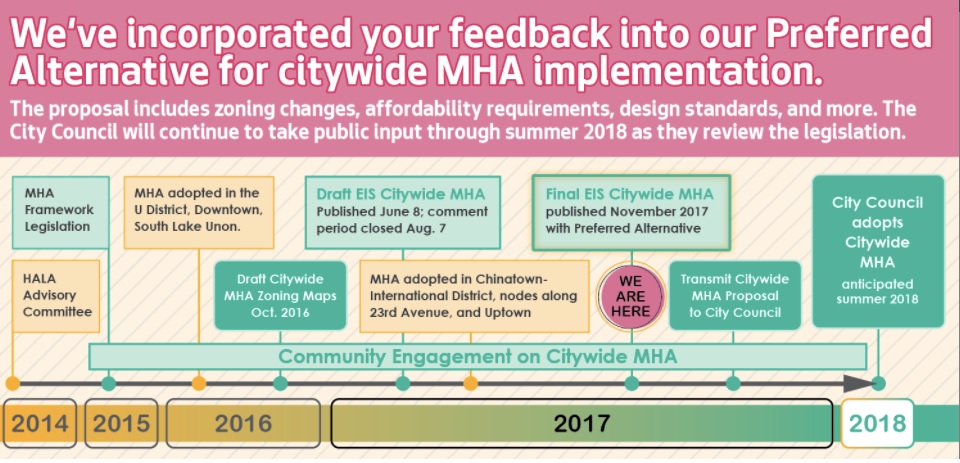
On November 9, the City released its Mandatory Housing Affordability (MHA) Environmental Impact Statement (EIS) that includes proposed changes to zoning in four areas of the Ravenna-Bryant neighborhood. This post is about proposed changes in the part of the neighborhood closest to the Roosevelt light rail station. Future posts will provide information about proposed changes to NE 55th Street, the Ravenna NE 65th Street business district, and to 35th Avenue NE.
What are MHA and EIS?
MHA is a new policy addressing Seattle’s growth, the need for more housing, and the desire to increase housing and jobs near frequent transit, in line with the City’s urban village strategy. MHA requires new development to either include affordable housing or contribute to a fund for producing affordable housing. In exchange, the City is increasing zoning capacity, allowing for taller buildings. MHA mostly encourages additional housing capacity in urban villages with easy access to transit.
The EIS identifies and describes potential impacts on the environment that could result from changing zoning associated with MHA policy. Environmental impacts were measured for:
- Housing & Socioeconomics
- Land Use
- Aesthetics
- Transportation
- Historic Resources
- Biological Resources
- Open Space & Recreation
- Public Services & Utilities
- Air Quality & Greenhouse Gas Emissions
What is proposed for Ravenna-Bryant?
After analyzing environmental impacts, the City came up with “preferred” zoning changes. The proposed preferred changes in the area of Ravenna-Bryant closest to the Roosevelt light rail station include expanding the Roosevelt Urban Village boundary from 15th Avenue NE to 17th Avenue NE and changing zoning designations as follows:
- At the east corner of NE 65th Street and 15th Avenue NE, increase capacity from Neighborhood Commercial 2, 40 feet (NC2-40) to Neighborhood Commercial 2, 55 feet (NC2-55);
- On 15th Ave NE, north of NE 63rd Street and south of NE 68th Street, increase capacity from detached Single Family (SF) to Lowrise 2 (LR2);
- On the north side of NE 65th Street west of 17th Ave NE, increase capacity from SF to Lowrise 1 (LR1);
- The remaining urban village expansion area would increase capacity from detached SF to Residential Small Lot (RSL).

What do these zoning designations mean?
Residential Small Lots: These areas would remain zoned for detached homes and would allow for property owners to build detached homes for multiple single families on one lot. Examples include skinny houses with the front of each house facing the street; “tandem” houses with one facing the street the other behind it; or “cottages” up to 650 square feet each.
Lowrise 1: Provides a transition between SF areas and multifamily and commercial areas. A mix of housing types similar in scale to detached single family homes such as cottages, rowhouses, and townnhouses are encouraged.
Lowrise 2: Allows for a variety of multifamily housing types in existing multifamily neighborhoods and along arterial streets. A mix of small scale to multifamily housing such as townhouses, rowhouses, and apartments are encouraged.
Neighborhood Commercial: A moderately-sized pedestrian-oriented shopping area that provides a full range of retail sales and services to the surrounding neighborhood. Typical land uses in NC2 zones include medium-sized grocery stores, drug stores, coffee shops, customer service offices, medical facilities, and apartments. Non-residential uses typically occupy the street front.

What’s next?
The MHA EIS is now in the hands of the City Council. After considering the EIS and holding public hearings, they will take action in 2018. Amendments to the official zoning map, amendments to the text of the Land Use Code, and changes to maps and policies of the Comprehensive Plan will need to be made.
Thanks for this!