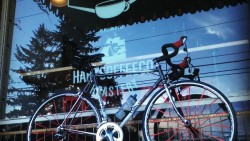
Neighborhood business Ventoux will co-host a local bike ride this weekend. Photo courtesy of the Ventoux Facebook page.
King County In Motion Ravenna-Bryant, Ventoux Coffee, and Seattle Neighborhood Greenways invite you enjoy a guided bike ride along the Burke-Gilman Trail and learn more about connecting to the UW Link Station and Matthews Beach on Saturday morning. Using your neighborhood greenways and bike paths, guides will lead two fun, family-friendly bike rides around your neighborhood:
a 6 mile roundtrip ride from Ventoux Coffee to the UW Light Rail Station.
a 11 mile roundtrip ride from Ventoux Coffee to the UW Light Rail Station and then to Matthews Beach.
Based on your skill level, preference, and interest you can choose which ride is right for you!
Register here. Meet at Ventoux Coffee (3404 NE 55th Street) at 10 AM on Saturday, July 9. Be sure to bring plenty of water, a helmet, and appropriate clothing.
This event will be led by Carlos Salmeron, owner of Ventoux Coffee and an avid cyclist; Andres Salomon, a neighborhood advocate from Seattle Neighborhood Greenways; and Carson Hartmann of the Ravenna-Bryant In Motion team. There will be complimentary coffee, a raffle drawing for a $25 gift card to Ventoux Coffee, as well as plenty of information about Metro, In Motion, bicycling, and more!
Do you live or work in Ravenna-Bryant and not already an In Motion participant? Sign up here!
The RBCA board of directors meets Tuesday, July 5, 6:30 p.m., at the Ravenna-Eckstein Community Center playground. (The community center building will be closed. In case of rain, we will meet at Harissa.) The board does not meet in August.
Board meetings are open to the public. Everyone is welcome!
AGENDA
6:30 Welcome & Introductions
6:35 Board Reports
Secretary’s Report: Minutes
Treasurer’s Report
Land Use Committee Report
Transportation Committee
In Motion event
#Fix65th Safety Walk
Mobility Assessment
7:05 Sameer Ranade, candidate State Rep for 43rd District
7:10 Learning more about proposed land use changes
Mandatory Housing Affordability (MHA)
ADU/DADU
Updates
Policies for discussion during future board meetings
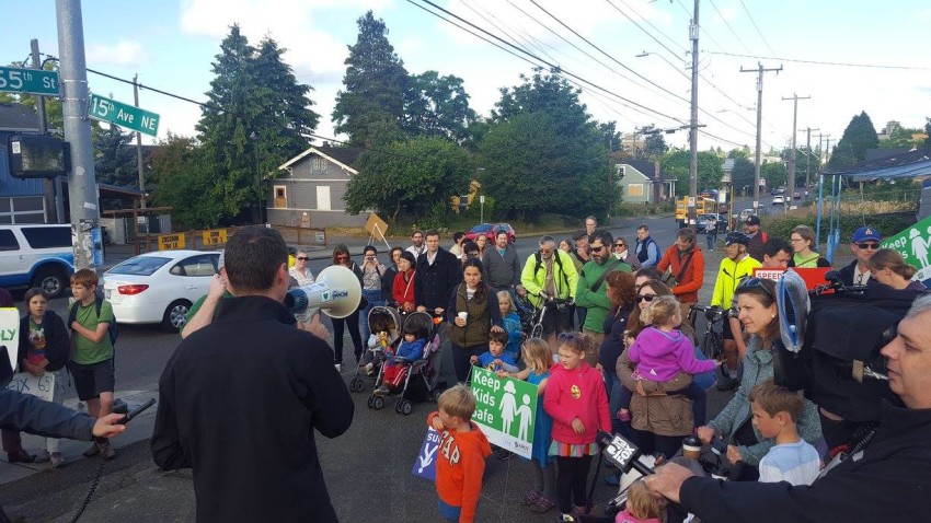
Councilmember Rob Johnson spoke to about 60 people who walked on NE 65th on June 16 demanding a safer street for all. Photo from Fix 65th Facebook page.
“The Seattle DOT signs saying “Stop for pedestrians” placed at random locations along NE 65th are confusing for car drivers (car drivers really shouldn’t stop for jay-walkers) and create a dangerous situation for pedestrians who think that cars will stop.”*
“Cars speeding at all hours of the day on 25th Ave NE between 65th and 55th. (especially during commute hours).”
“Narrow sidewalks close to traffic on 65th.”
“Cars consistently encroach upon crosswalk at NE 65th and 15th Ave NE.”
“Crossing NE 65th to get to Eckstein middle school is difficult and dangerous for children trying to get to school (and bus riders). Cars are going fast and don’t stop.”
“The slow change for pedestrian signals on NE 65th at Ravenna and 20th, the speed of traffic – cars don’t stop.”
“Walking across NE 65th is dangerous most of the time. Especially the intersections between 20th and 25th. Parked cars along 65th block views of drivers and peds and no one seems to remember that peds have right of way once they step into the street.”
These are just a few of the comments about NE 65th Street made by community members who recently took RBCA’s mobility assessment survey. Similar comments were made by Ravenna-Bryant and Roosevelt neighbors who marched on June 16 to raise awareness about the many motorists, bikers, and pedestrians who have been sent to the hospital after being involved in collisions on NE 65th Street. A Fix 65th coalition formed to further push for changes and is now circulating a petition asking SDOT to start the process soon.
The RBCA’s Mobility Assessment Task Force will wrap up assessment activities this summer and develop an action plan for addressing pedestrian, bike, and motor vehicle safety problems in our community, including NE 65th Street. Interested in being a part of the solution? Contact RBCA or attend the July 5 board meeting to learn more.
——-
*Seattle Pedestrian Law includes information about when motorists are required to stop for pedestrians.
You may have received a packet in the mail or visited the In Motion table at last night’s RBCA annual meeting. So, what is the campaign all about?
Metro Transit’s In Motion program is asking Ravenna-Bryant community members to pledge to drive less. By taking part in the program, residents can find more ways to give their car a break and explore healthier transportation options available in Ravenna-Bryant.
If you take the pledge by August 7, you can get an ORCA card good for two weeks of unlimited travel. After signing up, program participants will be entered in weekly drawings for gift cards to local businesses.
Ravenna-Bryant was chosen, along with Capitol Hill, for the In Motion program because of the recent opening of the Link light rail extension serving our neighborhoods. Since 2004, In Motion has provided 36 King County neighborhoods and communities with tools and information about how residents can explore healthier travel options.
This In Motion map for Ravenna-Bryant is available online and was included in the program’s recent mailing.
Speeding cars and difficulties crossing arterial streets are common mobility complaints from Ravenna-Bryant community members no matter if they are walking, biking, or driving a motor vehicle, according to preliminary results from an RBCA survey.
Earlier this year, RBCA formed a Mobility Assessment Task Force to identify neighborhood mobility-related problems and develop an action plan for addressing them. The need to proactively address problems became evident when mobility-related problems consistently were brought up during community meetings related to land use, public safety, and most proposed changes in Ravenna-Bryant.
Among survey responses, the most common (52%) were about walking, 23% about driving, and 17% about biking. Crossing all arterial streets was the primary concern specifically because cars are often speeding and because cars are parked too close to corners making it difficult to see oncoming traffic. For pedestrians, cars often do not yield to them when they are crossing streets and crosswalk lights are slow to change at 20th Avenue NE and in front of Assumption-St. Bridget School.
Not surprisingly, problems related to NE 65th Street predominate survey results, no matter the mobility mode. Crossing NE 65th Street is particularly difficult when drivers use it as a four lane road. Pedestrians report getting stuck halfway across when cars in one direction stop and cars traveling in the other direction do not. The corner of NE 65th Street and 15th Avenue NE is identified as particularly dangerous for a variety of reasons. Considering the Roosevelt light rail station will open in 5 years just a few blocks from this intersection, safety problems are especially concerning.
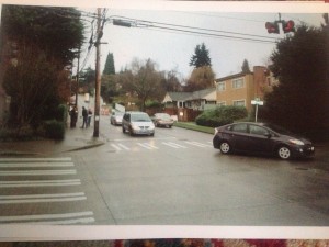
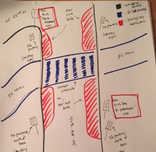
April 29 tweet from NE Seattle Greenways about the unsafe intersection at NE 65th Street and 15th Avenue NE. At the corner to the east of where this photo was taken stands a ghost bike in memory of Andy Hulslander who was killed here while biking home from work.
Both drivers and bikers identify traffic congestion and speeding motor vehicle drivers as common concerns. While bikers identify a lack of bicycle safety infrastructure as a problem, drivers commonly identify backed up traffic behind left-turning cars and at traffic signals.
The Mobility Assessment Task Force will complete our work this summer. The next meeting will be held in June with the date yet to be determined. If you are interested in being a part of the task force or RBCA’s Transportation Committee, please contact us.
The Ravenna-Bryant Community Association (RBCA) board of directors recently adopted a vision to guide activities. The vision puts in words what we would like Ravenna-Bryant to be like in 10-20 years.
Vision: Ravenna-Bryant is a welcoming, thriving, safe, diverse, and connected neighborhood.
One of the elements that impacts if our community is welcoming, thriving, safe, diverse, and connected is how people who live and work here, and those who visit our community, get around. The environment for walkers, bikers, motor vehicle drivers, and transit users is important for the future of our community.
So that RBCA can plan for a safe and welcoming environment for all to get around our community, we are establishing a plan that identifies current problems, identifies solutions that have worked for similar problems, and includes an action plan for implementing and advocating for solutions.
We are currently collecting information about specific problems in the Ravenna-Bryant community. (Please refer to the RBCA map to determine if a problem is located within our neighborhood.) We have collected information from previous surveys conducted by RBCA and the City of Seattle, through community and RBCA board meetings, and from our neighbors. We are now reaching out for more input.
Please click here to take the survey by April 30, 2016. You may take the survey as many times as needed.
Some problems already identified:
Unsafe walking and biking all around University Village. Unsafe connection for bicyclists between neighborhood streets and Burke-Gilman Trail. Some areas don’t have sidewalks or sidewalks in poor condition.
Unsafe pedestrian crossing at un-marked crosswalks along NE 55th, NE 65th, and NE 75th Streets.
Unsafe pedestrian crossing at un-marked crosswalks along 25th Avenue NE.
Unsafe pedestrian environments on some neighborhood streets because of speeding cars.
Insufficient car parking on 35th Avenue NE on weekends. Few places for bikes to park.
Motor vehicle traffic on NE 65th Street during rush hour.
Cars backed up at major intersections with no left-turn traffic signals.
Insufficient car parking around Ravenna-Eckstein Community Center when events in progress.
Unsafe bicycle environment along NE 65th Street, especially at 15th Avenue NE.
Unsafe bicycle environment along 35th Avenue NE.
Cars park too close to crosswalks/corners making it difficult for pedestrians, bikers, and motor vehicle drivers to safely cross street, especially along 35th Avenue NE.
Today, Sound Transit announced that the University of Washington Link light rail station at Husky Stadium will open on March 19, 2016.
Since the station is just two miles from Bryant Elementary School and less than that from some parts of the Bryant neighborhood, many of our neighbors will be using this station to get to Capitol Hill, Downtown, and points south. This is especially true for neighbors who bike, considering Ravenna-Bryant’s easy access to the Burke-Gilman Trail, or ride the bus.
Over at the University of Washington’s Transportation Services blog, they’ve been posting information about light rail and how UW employees and students can take advantage of it. Some of this information can be equally useful for Ravenna-Bryant community members who will access light rail at UW Station.
On November 3, Seattleites for the first time voted in district elections. Of the 55,309 registered voters in District 4, of which Ravenna-Bryant is a part, 26,068 (47%) returned ballots.
Voters in our community chose Tim Burgess and Lorena Gonzalez in the citywide council races and were in favor of Seattle Initiative 122 dealing with campaign finance. Except for the one precinct immediately east of the cemetery, Ravenna-Bryant voters chose Rob Johnson to represent District 4 on the City Council.
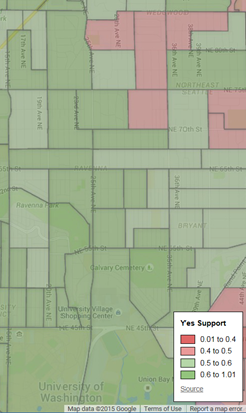
Map of Ravenna-Bryant precincts and how they voted in the District 4 City Council race. Blue precincts voted for Rob Johnson. Map thanks to www.philgardnerblog.blogspot.com.
Except for the precinct to the east and south of Eckstein Middle School, Ravenna-Bryant voters supported the Move Seattle Levy (Seattle Proposition 1).
Map of Ravenna-Bryant precincts and how they voted on Seattle Proposition 1, the Move Seattle Levy. Precincts shaded green voted in favor of the levy. Map thanks to www.philgardnerblog.blogspot.com.
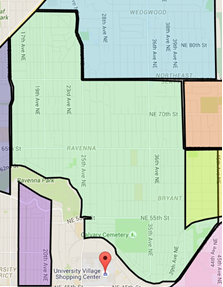
For reference, here is a map of Ravenna-Bryant in green.
Some of our Bryant and Ravenna neighbors are erecting PARK(ing) Day projects to make our streets safer tomorrow, Friday, September 18 between 10 a.m. and 7 p.m. These neighbors are parents of very young children who want to make their streets – and their neighborhoods – safer for their families and their community.
Winning designs from the first annual Seattle Neighborhood Greenways PARK(ing) Day Design Competition will be built this Friday. These are tactical urbanism projects – quick, inexpensive, and effective demonstrations of how streets can be safer for all of us. Projects celebrate safe streets for people.
Ravenna NE 65th & 20th NE. In Ravenna, Andres Salomon and his three-year-old son Atom are frequently out and about walking and biking in our community. Andres and his friends from NE Seattle Greenways will build a protected climbing lane for people who bike along NE 65th St between 20th Ave NE and 22nd Ave NE. Andres found that the sidewalk on this stretch of NE 65th was narrow, uneven, and often blocked by cars, while biking in the street felt very unsafe.
In support of PARKing Day projects, Zeeks Pizza is offering 15% off to anyone who mentions that they like the PARKing Day project in front of their restaurant.
Plans for the PARK(ing) Day event in Bryant.
Here is a link to the Ravenna project: https://twitter.com/NEGreenways/status/643210336540098560
Bryant Burke Gilman Trail & 40th NE. In Bryant, Kenneth Trease, father of two young children, and Jen Goldman, mother of three whose oldest is celebrating her sixth birthday on Friday, will build a protected crossing in a high conflict area for people who walk, bike and drive at 40th Ave NE and the Burke-Gilman Trail.
Jen says, “I am providing mini cupcakes to hand out. Sort of a shared birthday party for my daughter, who loves to bike and frequently crosses there. She is turning six on Friday. She is excited about the idea of getting a nicer spot to cross for her birthday!”
Here is a link to the Bryant project: https://twitter.com/NEGreenways/status/643212933208477697
PARK(ing) Day is an annual worldwide event where artists, designers, and ordinary people improve streets and transform on-street parking spaces into temporary parks for a day. It is an official Seattle event, with all temporary improvements requiring approval from the city.
The blue dot represents a current play street. The red dots are previous playstreets. Go to http://www.seattle.gov/transportation/playstreets.htm for the interactive map.
The Seattle Department of Transportation has a pilot program called Play Streets that will close your street down for play on a reoccurring basis. In 2014, there was a block (shown to the left in the blue) that had a play street for every home Huskies football game. There is a nice Play Streets Handout you can pass around so we can get more dots on this map.
NATIONAL NIGHT OUT
Earlier this week we reported on National Night Out funds being available. National Night Out is sponsored by the Seattle Police Department as way to create community, and therefore deter crime. National Night Out is always the first Tuesday of August and you can apply by going to SPD’s website.
BLOCK PARTIES
As we reported last summer, if you decide that the first Tuesday in August for National Night Out isn’t a good time for your block to have a party, you can close your street down any time you wish as long as you follow the simple rules below:
Do not live on an arterial street,
Do not close your intersection,
Do not have a bus stop on your block,
Clean up and restore your street before 10pm,
Do not request more than one block party per month.
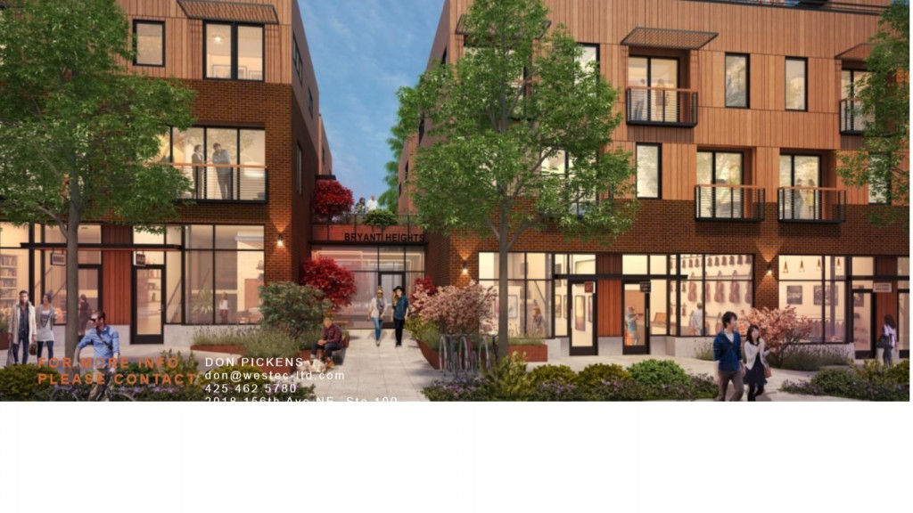
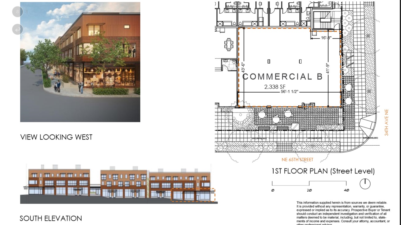
**UPDATE** We have received this message today, June 8th, 2015 about the status of the restaurant application process: “Thank you to the community members who have given input on the types of restaurants you would like to see at the new Bryant Heights development. One of our most successful experiences was a community member telling a restaurant about opportunities at Bryant Heights. The restaurant called their Broker and had them contact us. We had good discussions and in the end the restaurant operator decided the opportunity was not the right fit for them. Please keep talking to your favorite restaurants and encouraging them to check us out. We appreciate the community input and help in finding some restaurant concepts that will be great additions the neighborhood”
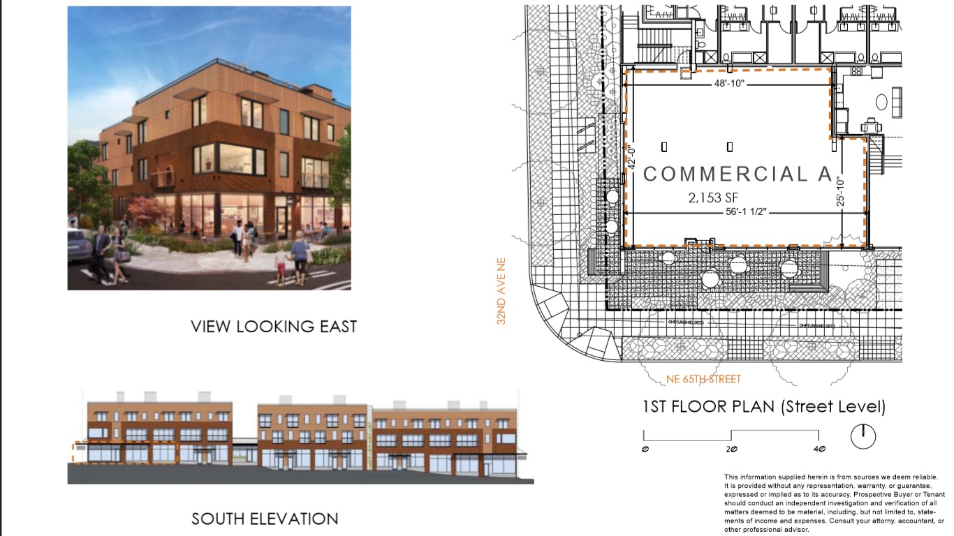
Polygon Northwest, the developers of the Bryant Heights project, would like the neighborhood to have a say in what kind of restaurant (or retail) should go into the two “bookend” spaces on NE 65th, on the corners of 32nd and 34th Avenue NE. Neighbors are encouraged to print out/email this PDF (Leasing_Bryant_Heights) and take it to your favorite restaurateur.
Both commercial spaces are over 2,000 square feet and include outdoor eating space. There will be a total of 10 car parking spaces and parking for 73 bikes on NE 65th, 32nd NE, 34th NE, as well as inside the garage.
In a survey that RBCA did in late 2013, 75% of the people who patronized businesses on NE 65th lived within 10 blocks, and new businesses opening along will make it easier for people to go to restaurants and stores without having to fight traffic. Also, the number of families in RBCA has increased in the past ten years, and many of those bike or walk to school.New restaurants in our neighborhood that cater to the walk/bike crowd are already coming to NE 45th and further west on 65th.
The 35th Ave Committee’s final report also clearly shows that the neighborhood would like to see more viable retail and a more walkable business district. Although the Bryant Heights project is not on 35th Ave NE itself, it is still considered part of the 35th Ave Business District. Very little new development with commercial space is being built in our neighborhood, so this is a rare opportunity to take part in shaping the future of our community.
What would YOU like to see in this new commercial space? Please help spread the word by telling your neighbors and talking to your favorite restaurateurs.
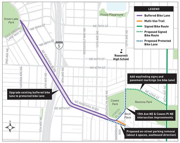
The proposed project would require moving or even removing parking along some parts on Ravenna Boulevard and 12th. It will also install a new protected bicycle lane on 15th adjacent to Cowen Park and links into the broader Bicycle Master Plan. Funding comes from the 2006 Bridging the Gap levy.
And here’s a map of the project area:
Project Area
Can’t make it to the open house but want SDOT to hear your input? Adan Carrillo is the project’s Community Outreach Specialist at Adan.Carrillo@seattle.gov or (206) 684-8105.
Footnote: the Ravenna-Bryant Community Association will meet that evening at 7pm at the Ravenna Eckstein Community Center for its monthly board meeting. Feel free to drop in and join us after the SDOT presentation.
Folks, it is time again to gather in the Teen room at the Ravenna-Eckstein Community Center at 7 pm to discuss topics near and dear to our community. Per Johnson from the Wedgwood Community Council will be joining us to talk about the proposed sale of the Children’s Home Society of Washington property. Albert Shen, who is running for City Council will be visiting us as well. We expect a lot of discussion around transportation and pedestrian issues in and around Children’s Hospital and NE 75th.
We’re also looking for some great people to join the Board and run for office!
The Agenda as it stands (subject to change)
Agenda
May 7, 2013 7-9 PM
Ravenna Bryant Community Association
Board of Directors Meeting
Ravenna Eckstein Community Association
7:00 Introductions (Jorgen)
7:05 Board Business (Various)
• President’s report – SNAP
• Nominations for President (Jorgen)
• Treasurer’s report/Minutes (none for April Community Meeting)
• NEDC update (Tony)
• April Community Meeting Debrief
7:20 WCC/35th Ave NE Neighborhood Planning District conversation with CHSW (Per)
7:35 Discussion on our next steps, including meeting with CHSW in a smaller group (All)
7:50 Albert Shen – Candidate for Seattle City Council (Albert Shen/Jorgen)
8:05 Updates from Jenny and the City (Jenny)
8:15 Transportation updates (various)
• Improvements at NE 75th and further plans for improving pedestrian safety
• Upcoming/Potential improvements at Blakeley (potential charrette with CBE)
8:30 Pedestrian Issues – (various)
• 40th Ave NE and B-G trail (Josephine)
• Sidewalk encroachment (Jorgen)
• NE 55th and 39th NE (Jorgen)
8:45 Old Business (All)
8:55 Adjourn
Next meeting – June 4, 2013
Jorgen Bader serves as representative of the University District Community Council and Virginia Gunby is a RBCA Board Member. Both served on the recent Westside 520’s Seattle Community Design Collaborative (SCDC) representing the interests of the University District and Ravenna-Bryant neighborhoods.
On October 26th, The Seattle Times reported that, thanks to project savings and an approved Federal loan, the funding gap for the construction of the Westside SR 520 segment had been reduced from $2 to $1.4 Billion. If the 2013 state Legislative Session approves I-90 tolling to fund the balance, then WSDOT will move forward with the construction/stabilization of the “Land to Lake” section on SR 520.
On the mornings of November 26th and December 10th, WSDOT staff will be briefing the Seattle City Council on the most recent plans for the new SR 520 Project at the City Council Chambers. The hearings will be open to the public. We urge that you let the city know your 520 thoughts and questions by testifying or by e-mail to the Council members or Mayor. The latest SR 520 designs are on the WSDOT website at www.wsdot.wa.gov/projects/srs520bridge/I5toMedina. Visit the site to check the graphics out!
I-5 to Medina Project Map
Current Issues awaiting Decision
After 15 years of study, many Public Meetings and input on the recent SCDC design refinements, consultants hired by the City of Seattle have recommended the removal of the second parallel Montlake Bridge across the Cut. The second bridge was part of the FHWA FEIS for SR 520 Westside Design as stated in Resolution 34111 approved in 20xx. With the forecasted increase in foot, bus and light rail traffic for the new Husky Stadium area Light Rail Station scheduled to open in 2014, planners expect traffic congestion for all modes will increase on the existing bridge. With increased number of traffic lanes on the south and north sides of the Montlake cut there is little support from the city transportation planners to improve the space for movement of Transit, Autos/Freight, Bikes or Pedestrians to move on Montlake Boulevard. (The Montlake Community has opposed the second Montlake Bridge, since they believe it will bring more traffic through their neighborhood.)
The design of the Portage Bay Bridge
Should the bridge be designed using a Box Girder design, similar to the current one, or a new cable-stay bridge? For those who don’t know the finer details about bridge design, the Box Girder supports the roadway with many pilings in the water whereas a cable-stay Bridge has a mast like a sailboat. The cable stay bridge’s cables spread like a sail down to hold up the roadway with less in water construction work on pylons, thus lessening the future impacts on the Portage Bay environment or users. Cable stay supporter believe the unique design for Seattle would be an appropriate “welcoming” design to the city entrance, consistent with the, surrounding moorages and water related activities.
An Additional Bike/Pedestrian Lane to connect with a bike trail at Roanoke to the Lake Union Trail and connecting to other N/S existing Trails as an alternative to using the hill climb route up Del Mar drive is planned. The bridge neighbors want a narrow design, and METRO opposes losing one lane, which could become a reversible lane, even though they connect only to the I-5 Express lanes that are only operated south in the AM and north in the PM. Bridge experts claim retrofitting it later for a Bike lane after it is built would be expensive. The bike community is strongly in favor of the addition of this Bike/Pedestrian lane.
Wetlands, lagoons and upland shorelines rehabilitation around Lake Washington Blvd, Foster Island Drive in order to reduce SR 520 impacts. The 520 plan includes the removal of existing SR 520 ramps. WSDOT has offered to give the City the adjacent west side wetlands for mitigation in exchange for dry lands by the roadways. So far the Council and the Mayor have not shown any interest in acquiring this area adjacent to the Arboretum.
West Side impacts and construction
Due to limitations of project funding, and the need to rebuild aging Pontoons and in water transition road supports, built before current earthquake standards, the Seattle land- side between I-5 and the Lake is the last scheduled to be funded and constructed. When completed, it will have six not four lanes, with two-way center Transit/HOV lanes, a bike/pedestrian lanes on the North side of the bridge and new safety shoulders. The design calls for construction of two lids above the 520 corridor near the Arboretum and Roanoke Avenue.
Lid Development
Another Community landscaped lid will be located on Capitol Hill near Roanoke. The design also requires collection and treatment of the all 520 roadway rain run-off in natural ponds, before releasing the clean water into the adjacent waters. In addition, traffic mitigation and calming on Montlake and pedestrian underpasses are included in the project. Construction best management practices will be used to reduce disruption and noise to adjacent Communities and protect or restore the surrounding community and roadside environment.
West Side Open House – WSDOT plans to have another SR 520 West side “Open House” to get Public Input in January, 2013. Stay tuned.
Neighborhood Greenways make it safe and easy for everyone to get around the city
Are you interested in a transportation system that works for all users? With park-like streets in our neighborhood that are safe and enjoyable for walkers and cyclists of all ages?
Community members across Seattle have been coming together in the past year and a half to develop plans for Neighborhood Greenways – designated streets that prioritize pedestrian and bicycle use and connect to parks, schools, and neighborhood businesses.
The first Neighborhood Greenway project in our community will likely be along 39th Ave. NE from the Burke-Gilman to NE 75th St. This first Greenway may be constructed this coming summer!
RBCA’s Spring membership meeting (April 3, 2012 – 7 p.m.
Ravenna-Eckstein Community Center) provides a great opportunity to learn more about these greenways, through a presentation by Councilmember Sally Bagshaw, who is an avid supporter of this initiative. After the presentation there will be plenty of time for questions and discussion.
Neighbors are talking about 27th Ave. NE and 45th Ave. NE as possibilities for future Greenways, and about the need to provide a system that provides better connections for pedestrians and bicyclists to the forthcoming Roosevelt light rail station, Green Lake Park, the University District, and other neighborhood hubs.
The Wedgwood Community Council recently published a great overview of local efforts at http://wedgwoodcc.org/greenways-coming-to-a-street-near-wedgwood. Check out the information on Childrens Hospital’s Livable Streets Initiative, and the Portland video that shows how they’ve approached Neighborhood Greenways down there.
A NE Seattle Neighborhood Greenways group has recently formed to help flesh out ideas for local routes. More information is available at http://www.facebook.com/NESeattleGreenways.
What will Neighborhood Greenways mean for Ravenna/Bryant? And how can you get involved and lend your voice to the discussion? Come hear from Councilmember Bagshaw on Tuesday and find out!
This week holds a plethora of community-related meetings, for the civically-inclined:
Roosevelt Neighborhood Association general meeting, Tuesday, May 24, 7:15-9:30PM, Calvary Christian Assembly Roosevelt High School, Room 242, 1410 NE 66th St
Agenda includes an update on the rezoning in the Roosevelt neighborhood.
SR 520 Drop-in Information Session, Wednesday, May 25, 6-8PM, Ravenna Third Place Books (public meeting put on by the Washington State Department of Transportation)
Coalition for a Sustainable SR 520 and Laurelhurst Community Club, Wednesday, May 25, 7-8:30PM, Laurelhurst Community Center, main floor activity room, 4553 47th Ave NE (more information on this meeting available here)
North Link Light Rail Roosevelt Station meeting, Thursday, May 26th, 6-8:30PM, Ravenna-Eckstein Community Center, 6535 Ravenna Ave NE
[Part of this post was previously seen on the Ravenna Blog here.]
 u may have received a packet in the mail or visited the
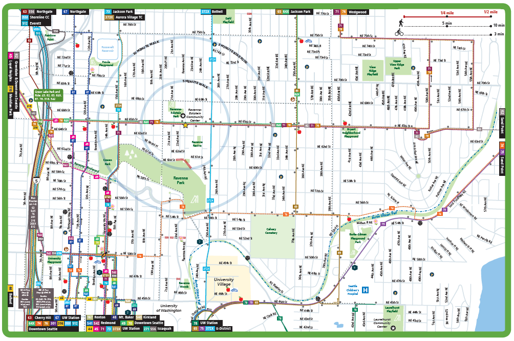
 Speeding cars and difficulties crossing arterial streets are common mobility complaints from Ravenna-Bryant community members no matter if they are walking, biking, or driving a motor vehicle, according to preliminary results from an RBCA survey.
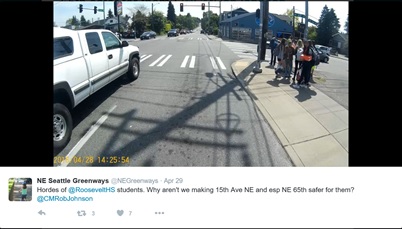
 The Ravenna-Bryant Community Association (RBCA) board of directors recently adopted a vision to guide activities. The vision puts in words what we would like Ravenna-Bryant to be like in 10-20 years.