Take a public safety survey to guide SPD neighborhood policing plans

Public Safety SurveySeattle University is administering the citywide Seattle Public Safety Survey. The purpose of the survey is to solicit feedback on public safety and security concerns from those who live and/or work in Seattle. From October 15th through November 30th it is accessible at publicsafetysurvey.org  and is available in Amharic, Chinese, English, Korean, Somali, Spanish and Vietnamese.

A report on the survey results will be provided to the Seattle Police Department to assist them with making your neighborhood safer and more secure.

Virginia Gunby thanked for her service to the community

By Jorgen Bader, RBCA Vice President

With regret, the RBCA Board accepted the resignation of the long-serving chair of our Transportation Committee. Virginia Gunby accepted the position of Transportation Committee chair in order to assist our community in opposing a design proposed by the Washington State Department of Transportation (WSDOT) in July 2006 for rebuilding State Route 520.

The design proposed was a massive concrete interchange, like those in industrial areas. It included tall stilts over Union Bay with ramps taking up the south Husky Stadium parking lot and the widening of Montlake Blvd NE. As a result of the public outcry, the 2007 legislature required WSDOT to go through a mediation process with a panel of representatives from the affected communities. The process lasted through December 2008 and Virginia spoke for RBCA.

Virginia led the coalition that developed the design which became the basis for the current plan. Throughout the many meetings, some very contentious, Virginia had the persuasive skills, patience, and diplomatic ability to bring others around on many key issues.  The mediation process was followed by the environmental reviews procedures, follow-up WSDOT consultations, and then lengthy City Council review and revisions that continued for years. Virginia advocated for lanes for transit and high occupancy vehicles, lids and other measures to mitigate environmental damage, and coordination with Sound Transit.

Back in the 1960’s, Governor Dan Evans appointed Virginia to the then State Highway Commission. As a commissioner, she pushed for the design of I-90 to consider environmental values and for special lanes for transit. She is co-founder and was president of 1000 Friends of Washington, now called Futurewise. Virginia served as a freeholder in framing the 1968 King County Charter and served on two of its review commissions. She chaired a Growth Management Committee for the Puget Sound Regional Council and held important positions on the King County legislative and executive staffs. Virginia has also been a senior official in the League of Women Voters. Her views always carry clout.

Over the years, Virginia was also in the forefront for locating the Sound Transit Station in the Roosevelt business district (rather than next to I-5); against cutting Metro bus service to our neighborhood; and for roadway improvement measures.

Virginia retired from the RBCA board to dedicate her time curating the records of Margaret Tunks, founder of Citizens Against Freeways, for the UW. We will greatly miss her contributions to RBCA.

How should Ravenna-Bryant grow?

How do we want the Ravenna-Bryant neighborhood to grow over the next 20 years to best accommodate the increased number of people who will be living in Seattle? Do proposals in the drafted Comprehensive Plan, including the expansion of the Roosevelt Residential Urban Village into part of Ravenna, make sense or should increased housing and related infrastructure be spread more evenly throughout Ravenna and Bryant? How do the recommendations in the Mayor’s Housing Affordability & Livability Agenda (HALA) for increasing affordable housing intersect with the Comprehensive Plan and what do they mean in our community? These are just some of the questions RBCA board members began discussing this past week.

To get questions answered and provide the Seattle Department of Planning and Development (DPD) with input, community members are invited to check out the Key Proposals at one of their upcoming open houses. At the meetings you can learn more about what’s proposed and chat with staff to share your thoughts and ask questions. DPD will have information available about the potential expansion of urban villages and HALA.

Open house dates & locations

  • October 19, 6:00 to 8:00 p.m. (presentation at 6:30 p.m.), Miller Community Center, 330 19th Ave E.
  • November 5, 6:00 to 8:00 p.m. (presentation at 6:30 p.m.), Leif Erikson Hall, 2245 NW 57th St.
  • November 7, 9:00 a.m. to 12:00 p.m.(presentation at 10:00 a.m.), Filipino Community Center, 5740 MLK Jr Way S.
  • November 12, 6:00 to 8:00 p.m. (presentation at 6:30 p.m.), Senior Center of West Seattle, 4217 SW Oregon St.
  • November 14, 9:00 a.m. to 12:00 p.m.(presentation at 10:00 a.m.), North Seattle College, 9600 College Way N.

Online feedback
You can submit your comments on the Draft Plan through November 20.  Here’s how:

1. Join the Seattle 2035 Online Community Conversation at seattle2035.consider.it and discuss the potential pros and cons of Key Proposals with fellow Seattleites.

2. Follow on Facebook and Twitter

3. Send comments by November 20, 2015:

  • Email: 2035@seattle.gov
  • Mail comments to the City of Seattle Department of Planning and Development, Attn: Seattle 2035, 700 5th Avenue, Suite 2000, PO Box 34019, Seattle WA 98124-4019.

Your feedback will help shape the Mayor’s Recommended Plan which will be sent to City Council in early 2016.

Ravenna-Bryant has how many restaurants?

If you had to guess, how many places to eat or drink do you think are in the Ravenna-Bryant neighborhood?  If someone said 35, would you be surprised?

sod house
A sampling of some of the food sold at Sod House Bakery, one of 16 places to get something to eat or drink along Ravenna’s “restaurant row.” Photo courtesy of Ravenna Blog, used with permission.

1. Third Place Pub
2. Vios
3. Zeeks
4. Bagel Oasis
5. Sod House Bakery
6. Crepe Café
7. Heidelberg Haus
8. Ravenna Alehouse
9. Muddy Waters Coffee
10. Varsity
11. Bai Pai
12. Sushi Wataru (coming soon)
13. Salare
14. Zouave
15. Harissa
16. daPino
17. Bryant Corner

third place pub yelp
Third Place Pub, in the basement of Third Place Books on the corner of NE 65th Street and 20th Avenue NE includes plenty of off-street bike and car parking. Photo courtesy of Yelp.

18. Kidd Valley
19. Krua Thai
20. Frank’s Oyster House
21. Queen Mary Tea
22. Duchess Tavern
23. Pair
24. Ventoux
25. Gaudi
26. Mioposto
27. Zoka
28. Mamma Melina
29. Plume
30. Pinkaew
31. McDonald’s
32. Subway
33. Papa John’s
34. Top Pot Doughnuts
35. Grateful Bread

franks-oyster-house_jen liu
Frank’s Oyster House on NE 55th Street. Photo by Jennifer Liu courtesy of Seattleite.

Coming soon: Ravenna Brewing Company and two new restaurants at the very south end of our community next to the Burke-Gilman Trail.

The abundance of places to eat and drink contributes to Ravenna and Bryant being considered very walkable and bikeable by Walk Score. Not to mention University Village, with its plethora of restaurants, is within easy walking and biking distance from a large portion of the neighborhood. Who needs to leave Ravenna-Bryant and be part of our city’s notorious traffic when you can walk or bike to a nearby restaurant?

Is this list missing a place to eat or drink in our neighborhood? Leave a comment below!

School Board Candidate Forum October 12

Seattle School Board Candidate Forum

Monday, October 12, 2015
Eckstein Middle School Auditorium
3003 NE 75th Street
7:30pm – 9:00pm

Learn more about the eight Seattle School Board candidates and what they think about the issues that matter – from school funding to standardized testing. The Eckstein Middle School PTSA, in collaboration with Eckstein students, is pleased to welcome parents, teachers, kids and community members to a moderated forum with Seattle’s candidates for School Board. Everyone is welcome!

SPD taking back unwanted prescription drugs September 26

TBYM sept 2015On Saturday, September 26 from 10 a.m. to 2 p.m. the Seattle Police Department and the Drug Enforcement Administration (DEA) will give the public its tenth opportunity in five years to prevent pill abuse and theft by ridding their homes of potentially dangerous expired, unused, and unwanted prescription drugs. Bring your pills for disposal to any police precinct. The North Precinct is located at 10049 College Way North.

The DEA cannot accept liquids or needles or sharps, only pills or patches. The service is free and anonymous, no questions asked.

This initiative addresses a vital public safety and public health issue. Medicines that languish in home cabinets are highly susceptible to diversion, misuse, and abuse. Rates of prescription drug abuse in the U.S. are alarmingly high, as are the number of accidental poisonings and overdoses due to these drugs. Studies show that a majority of abused prescription drugs are obtained from family and friends, including from the home medicine cabinet. In addition, Americans are now advised that their usual methods for disposing of unused medicines—flushing them down the toilet or throwing them in the trash—both pose potential safety and health hazards.

Celebrate PARK(ing) Day in Ravenna-Bryant Friday

Some of our Bryant and Ravenna neighbors are erecting PARK(ing) Day projects to make our streets safer tomorrow, Friday, September 18 between 10 a.m. and 7 p.m. These neighbors are parents of very young children who want to make their streets – and their neighborhoods – safer for their families and their community.

Winning designs from the first annual Seattle Neighborhood Greenways PARK(ing) Day Design Competition will be built this Friday. These are tactical urbanism projects – quick, inexpensive, and effective demonstrations of how streets can be safer for all of us. Projects celebrate safe streets for people.

Ravenna NE 65th & 20th NE. In Ravenna, Andres Salomon and his three-year-old son Atom are frequently out and about walking and biking in our community. Andres and his friends from NE Seattle Greenways will build a protected climbing lane for people who bike along NE 65th St between 20th Ave NE and 22nd Ave NE. Andres found that the sidewalk on this stretch of NE 65th was narrow, uneven, and often blocked by cars, while biking in the street felt very unsafe.

In support of PARKing Day projects, Zeeks Pizza is offering 15% off to anyone who mentions that they like the PARKing Day project in front of their restaurant.

PARKing Day 2015 B-G
Plans for the PARK(ing) Day event in Bryant.

Here is a link to the Ravenna project: https://twitter.com/NEGreenways/status/643210336540098560

Bryant Burke Gilman Trail & 40th NE. In Bryant, Kenneth Trease, father of two young children, and Jen Goldman, mother of three whose oldest is celebrating her sixth birthday on Friday, will build a protected crossing in a high conflict area for people who walk, bike and drive at 40th Ave NE and the Burke-Gilman Trail.

Jen says, “I am providing mini cupcakes to hand out. Sort of a shared birthday party for my daughter, who loves to bike and frequently crosses there. She is turning six on Friday. She is excited about the idea of getting a nicer spot to cross for her birthday!”

Here is a link to the Bryant project: https://twitter.com/NEGreenways/status/643212933208477697

PARK(ing) Day is an annual worldwide event where artists, designers, and ordinary people improve streets and transform on-street parking spaces into temporary parks for a day. It is an official Seattle event, with all temporary improvements requiring approval from the city.

District 4 Neighborhood Issues Debate October 14

Save the date!

City Council District 4
NEIGHBORHOOD ISSUES DEBATE
with Candidates Rob Johnson and Michael Maddux

Wednesday, October 14, 7:30 to 9:00 p.m.
Chapel (4th Floor) at the Good Shepherd Center
4649 Sunnyside Ave. N (Wallingford)

Do you have neighborhood-specific questions that you would like the candidates to address? Submit questions for both candidates about your District 4 neighborhood by October 9 by writing it in the comments section below.

Summary of RNA LUA Session 1

The Roosevelt Neighborhood Association (RNA) is hosting a Land Use Academy (LUA) made up of a series of five community forums. The first in the series, Roosevelt 101, was held July 25, 2015. A video of the first meeting may be viewed below and on YouTube.

Former RNA board member Jim O’Halloran moderated the forum, starting by saying that the idea behind the RNA LUA is to “empower” the neighborhood, get everyone “on the same page,” and “have [our] voices heard.”  By the end of the LUC in Fall of 2015, he plans to produce some “statements” about the three main issues Roosevelt is dealing with these days; the Sisley properties, the Transit Oriented Development (TOD) at the Sound Transit Station, and the possibility of the Roosevelt reservoir being decommissioned.

The new Director of the Department of Neighborhoods, Kathy Nyland, spoke around minute 6:00.  She started by saying that she thinks the City could do a better job getting people educated and empowered about the issues affecting them in their neighborhoods.  She would like to make this information more relatable and understandable; she cares less about the outcome of the LUA and more about the process itself.

At around 21:00, the City’s Department of Planning and Development’s (DPD’s) Ryan Moore spoke about the big picture, the City’s Comprehensive Plan, and how that gets translated into how a community actually looks and feels.  Ryan said that there aren’t other neighborhoods in the City that deal with neighborhood planning at the level of sophistication that Roosevelt does.

Renee Davis, a member of the group from the 1990’s called “Tomorrow’s Roosevelt” spoke (starting at 28:00) about the effort they lead to get consensus on the direction the residents of Roosevelt hoped their neighborhood would take.  She said that after an extensive survey (all hand-delivered), the overwhelming majority of Roosevelt residents wanted the light rail station underground and near the business core.  They also identified that they wanted the density associated with the new station to be tiered; tall buildings shouldn’t buttress single family homes.  They wanted parks and open space as well.  Most folks thought the reservoir should be a park, pool, or community center-they were told it would be “capped.”

Ravenna neighborhood activist Barbara Warren spoke (57:00) about the process of putting together the update to the Roosevelt neighborhood plan.  Barbara, a retired affordable housing lawyer, said the overriding objective for the 2006 neighborhood plan update was to plan for the increased density and growth targets.  The 2006 update ended up exceeding the growth targets given by the City.  The committee identified neighborhood priorities, again, through surveys. Respondents asked to absorb the density while maintaining the mountain views from Roosevelt High School (RHS), provide a range of housing options, and preserve the architecture of the single family homes.  The 2007 announcement by Roosevelt Development Group (RDG) to put 16 stories in front of RHS whittled down to a 2011 contract rezone for 12 stories.  The contract rezone application was never finished, however, as a 2012 legislative rezone increased the zoning in front of RHS from 4 stories to 6 stories.

Jim O’Halloran gets into the details of the legislative rezone around 1:11.  After Mayor McGinn changed the zoning from 4 stories to 6 stories in front of RHS, a plan called the “Sustainable Livable Roosevelt Plan” or SLRP offered more density along I-5 in the form of MR (mid-rise zoning that is being developed now) in exchange for leaving the 40′ zoning on the “Fruit Stand Block.”  All 9 City Council members came to RHS one night in 2011 to hear about 400 people stand up and give comment.  He said that in the end, “things didn’t turn out our way,” but the legislative rezone did give concessions to the neighborhood in the form of further setbacks from the street and designated green streets on NE 66th from 15th to 8th and 66th to Ravenna Boulevard, making the rezone “easier to swallow.”

At around 1:21 into the video, RBCA’s Land Use Chair Sarah Swanberg adds that Ravenna residents got involved in the Roosevelt rezone because 65th and 15th is the gateway to Ravenna.  Sarah felt that it was hard to make an informed decision about whether 6 stories in front of RHS would actually block the view of the mountains but, in the end, the decisions were made by people who showed up at the meetings.  Ultimately, the City Council made the call to put 6 stories instead of 4 in front of RHS.

The second forum, Current Issues in Land Use Planning, will take place Saturday, September 19. Visit the RNA website for more information.

More crisis intervention services needed in north Seattle

A recent Seattle Times article, SPD report: Minimal force used in contacts with mentally ill, highlights the large number of crisis calls police respond to. During a 90-day period, the North Precinct reported responding to 699 crisis calls out of a City total of 2,464. The North Precinct is second only to the West Precinct (reporting 719 crisis calls), which includes downtown, when it comes to responding to crisis calls.

The article echoes a letter the North Precinct Advisory Council’s (NPAC) Social Services Committee sent to King County Councilmember Dembowski this summer requesting additional funding for the Mobile Crisis Team. Following is an excerpt:

This year, members of the Seattle Police North Precinct Advisory Council (NPAC) formed committees to focus on public safety issues of particular concern to north Seattle residents. We are members of the Social Services Committee and one of our goals is to increase services in north Seattle to address social and health-related problems that police are often called to address. We are particularly interested in increasing mental health services to help police when they receive calls from community members to address crisis issues like suicidality and drug abuse.

 We are writing to you today to thank you for your continued support of the Mental Illness and Drug Dependency (MIDD) program and to urge you to increase funding in the next budget for the Crisis Solution’s Center’s Mobile Crisis Team. The expansion of the Mobile Crisis Team’s services would allow police to link more people with needed support.

 In a 90-day period, more than 700 north Seattle calls to 911 are deemed crisis calls. Of those calls, more than a quarter are related to suicide. In most cases, people facing these types of crises can be served better by the Mobile Crisis Team instead of police.

Right now, when police call the Mobile Crisis Team, it can take them anywhere from about 30 minutes to four hours to respond to the crisis. The longer the response time, the more missed opportunities to serve our neighbors in need. To gain more service with faster response times, police need to call the Mobile Crisis Team more often so that their statistics reflect the need. However, if response times are up to four hours, police are less likely to call. This, in turn, means that call data kept by the Mobile Crisis Team may not reflect the true need in the north end. Increased availability of the Mobile Crisis Team would increase use of the program by police and would better serve people in crisis.

The North Precinct Advisory Council is a community organization devoted to promoting partnership between residents, schools, businesses, and the Seattle Police Department to effectively address public safety issues. NPAC members represent community associations and other groups located in the North Precinct. NPAC meets the first Wednesday of every month at North Seattle Community College. All meetings are open to the public.

Tips for keeping kids safe on their way to and from school

Bryant Elementary Waslking School BusOne of the most common public safety complaints made by Ravenna-Bryant neighbors is about pedestrian, bike, and traffic safety. With the start of a new school year upon us and less daylight, now is a good time to remember safety tips. Here are a few from SPD North Precinct Captain Sean O’Donnell, who attended schools in the Ravenna-Bryant area during his childhood.

For drivers

  • Abide by speed limits, especially when entering a school zone. Speeding in a school zone can result in a $214 ticket.
  • Watch for children entering the street from behind buses or running to catch a bus.
  • Drive slowly when approaching children riding bicycles and walking near the street.
  • Never pass or overtake a vehicle that is stopped at a crosswalk. A pedestrian is probably in the crosswalk. Doing so can result in a $136 ticket.
  • Pedestrians have the right of way at ALL intersections, whether in a marked crosswalk or not. On a two-lane road, the pedestrian must be completely across the roadway before drivers begin moving again.
  • Do not drive distracted (cell phone, eating, etc.)
  • NEVER DRINK AND DRIVE or drive under the influence of drugs.

For pedestrians

  • Pay close attention to surroundings, avoid being on “automatic pilot.”
  • Pick routes with good lighting, clear visibility, and sidewalks. If there is no sidewalk and you must walk in the road, always walk facing traffic. See and be seen – drivers need to see you to avoid you.
  • Plan a safe walking route to school that is direct with the fewest street crossing and, if possible, with intersections that have traffic controls.
  • Pedestrians do not have the right of way when crossing mid-block. Cross streets only at corners, marked crosswalks, or intersections.
  • Avoid walking while listening to an iPod, cell phone, or other device with ear buds or headphones. Like with drivers, these cut down on your awareness of what’s happening around you.

Better know a neighborhood: Ravenna-Bryant zoning, NC2P-40

By Inga Manskopf, RBCA President

As I wrote in a previous post, so much of our local civic conversation is around land use these days. As we discuss how the use of land in our communities may or may not change within the next twenty years, it’s important to know where we are now.

Zoning in Ravenna-Bryant

I recently took a look at a zoning map for my immediate neighborhood (surrounding Bryant Elementary, area 62 on the zoning map). While the vast majority of the area is zoned Single Family, land along NE 55th and NE 65th are zoned differently. A zoning map of NE 55th between 25th and 35th Avenues shows multiple designations and that much of the area is ripe for increased development.

The northwest corner of NE 55th and 35th Avenue NE is zoned NC1-40. The previous post describes NC1-30 zones. Add 10 more feet and you have NC1-40.

55th and 35th
From the northwest corner of 35th Avenue NE to the alley, NE 55th Street is zoned NC1-40 or Neighborhood Commercial up to 40 feet tall (generally 4 stories). Currently, the land contains single story buildings. The rest of the block is zoned NC1-30 or Neighborhood Commercial up to 30 feet tall.

What is NC2-40?

Further west on NE 55th Street, starting at 30th Avenue NE (where Pair is located) all the way down the hill through 25th Avenue NE, zoning on both sides of the street changes to NC2P-40 or Neighborhood Commercial 2 Pedestrian, 40 feet high. (The pedestrian designation was added earlier this year.)

Typical land uses in NC2 zones include medium-sized grocery stores, drug stores, coffee shops, customer service offices, medical facilities, and apartments.  Non-residential uses typically occupy the street front.

City code defines NC2 as meeting the following function and location criteria.

Function: To support or encourage a pedestrian-oriented shopping area that provides a full range of household and personal goods and services, including convenience and specialty goods, to the surrounding neighborhoods, and that accommodates other uses that are compatible with the retail character of the area such as housing or offices, where the following characteristics can be achieved:

  • A variety of small to medium-sized neighborhood-serving businesses;
  • Continuous storefronts built to the front lot line;
  • An atmosphere attractive to pedestrians;
  • Shoppers can drive to the area, but walk from store to store.

Location: A Neighborhood Commercial 2 zone designation is most appropriate on land that is generally characterized by the following conditions:

  • Primary business districts in residential urban villages, secondary business districts in urban centers or hub urban villages, or business districts, outside of urban villages, that extend for more than approximately two blocks;
  • Located on streets with good capacity, such as principal and minor arterials, but generally not on major transportation corridors;
  • Lack of strong edges to buffer the residential areas;
  • A mix of small and medium sized parcels;
  • Limited or moderate transit service.
Drawing courtesy of Department of Planning and Development

Adding the designation of a pedestrian retail area to the NC zone:

  • Preserves areas that offer a mix of street-level, pedestrian-oriented destinations accessible by foot, bike, and transit;
  • Identifies and encourages areas that have potential to transition to a pedestrian-oriented neighborhood business district;
  • Encourages more walking, biking, and transit use to and within neighborhood business districts by preserving and promoting active destinations.

In pedestrian zones:

  • Residential uses may occupy no more than 20% of the street-level street-facing building facade.
  • Buildings cannot have large blank facades on the street-facing pedestrian level.
  • A parking lot on the building site cannot be in front of the building or abut the street. Parking must be under the building or behind it.

Better know a neighborhood: Ravenna-Bryant zoning – NC1

By Inga Manskopf, RBCA President

HALA! City of Seattle Comprehensive Plan! Urban villages and urban centers! So much of our local civic conversation is around land use these days. As we discuss how the use of land in our communities may or may not change within the next twenty years, it’s important to know where we are now.

Zoning in Ravenna-Bryant

I recently took a look at a zoning map for my immediate neighborhood (surrounding Bryant Elementary, area 62 on the zoning map). As expected, most of the area is zoned Single Family 5000, meaning most homes need to be on 5000 square foot lots. However, land along NE 55th and NE 65th is zoned differently.

For example, the land on NE 65th Street between 31st and 35th is zoned NC1-30, or Neighborhood Commercial 1, 30 feet high.

65th and 35th south side
NE 65th Street just west of 35th Avenue NE, south side, is zoned Neighborhood Commercial. Currently, these buildings are not used for commercial purposes.

What is NC1-30?

According to City Land Use Code, Neighborhood Commercial 1 (NC1) zones have the following function and location criteria.

  • Function: To support or encourage a small shopping area that provides primarily convenience retail sales and services to the adjoining residential neighborhood, where the following characteristics can be achieved:
    1. A variety of small neighborhood-serving businesses;
    2. Continuous storefronts built to the front lot line;
    3. An atmosphere attractive to pedestrians;
    4. Shoppers walk from store to store.
  • Location: A Neighborhood Commercial 1 zone designation is most appropriate on land that is generally characterized by the following conditions:
    1. Outside of urban centers and urban villages, or within urban centers or urban villages where isolated or peripheral to the primary business district and adjacent to low-density residential areas;
    2. Located on streets with limited capacity, such as collector arterials;
    3. No physical edges to buffer the residential areas;
    4. Small parcel sizes;
    5. Limited transit service.

The 30 in NC1-30 means that building cannot be taller than 30 feet, generally up to three stories.

Drawing courtesy of the Department of Planning and Development.

Next up: I will take a look at NE 55th Street, which has multiple zoning designations.

Do you know how your immediate neighborhood is zoned?

Find out how the land in your part of the neighborhood is zoned. The Department of Planning and Development has maps easily accessed online at: http://www.seattle.gov/dpd/toolsresources/zoningmapbooks/default.htm.

Definitions may be found in the Seattle Land Use Code: http://www.seattle.gov/dpd/codesrules/codes/landuse/default.htm. Definition summaries are located online, too: http://www.seattle.gov/dpd/codesrules/codes/zoning/default.htm.

RBCA expresses accessibility concerns with proposed changes to Metro service

Earlier this month, the Ravenna-Bryant Community Association Board sent a letter to King County Executive Dow Constantine about proposed changes to bus service in our community once light rail is available in the University District. Below is the letter and the response from Kevin Desmond, General Manager of Metro.

Dear Executive Constantine,

On behalf of the Ravenna-Bryant Community Association (RBCA), I am writing to offer comments regarding the proposed King County Metro (Metro) route restructure associated with the opening of Sound Transit’s University Link Light Rail (LINK). While RBCA finds many positive changes associated with the new service plan for Ravenna-Bryant, we also have concerns with specific components of the plan that do not take into account accessibility for all people who use transit.

Bus-Rail Connection at Husky Stadium

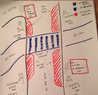
RBCA is concerned that the bus-rail connection between the routes serving Northeast Seattle is inadequate. The University of Washington Husky Stadium Station is in a challenging location to serve with a convenient bus connection, separated from Upper campus by Montlake Boulevard, which is often gridlocked in the southbound direction. In particular, the connection from the station to the closest Route 372 stop is, by our estimation, over 500 yards from one existing bus stop on Stevens Way and over 600 from the other. Even with the recently constructed land bridge over Pacific and pedestrian bridge over Montlake, this connection is sub-optimal in terms of time for the able bodied and unacceptably far for those who are not. Transferring between buses and trains should be quick and easy to navigate. With this problem in mind, we offer three suggestions, with reference to the attached Metro route map for the Montlake Triangle area:

• Loop the Route 372x, or some number of the Route 372x runs, such that the northbound route uses Montlake Boulevard, as the 65 is planned to do. This would allow the mobility impaired direct access to and from the station, while giving everyone a much more seamless connection from LINK to Northeast Seattle going north.

• Create a bus stop along Stevens Way directly in front of the land bridge pathway, which would reduce the walk by 150 yards. This would create a closer connection and a much better perception of connection to the station (and perhaps safety) by having the LINK station in direct line of sight from the drop off points.

• Work with Sound Transit to add more secure bike parking spaces, as only 140 total are planned for a station that is at the end of the high-capacity line, on a university campus, and adjacent to one of the most heavily utilized bike trails in the country.

Over the long-term, we hope Metro can work with SDOT and UW to create a more permanent fix to the situation by creating a southbound HOV lane along Montlake Boulevard or transit access through the UW parking lots.

Direct Bus Service to the University District

Metro plans to eliminate Route 71, which currently links Ravenna-Bryant with the University District and Downtown, with Route 16 which will bypass the University District on its way to Seattle Center. While we appreciate the renewed direct connection to Seattle Center, RBCA is concerned about losing a bus route that directly links community members to the University District and South Lake Union. Transferring from the new Route 16 to LINK at the Roosevelt station or another bus to get to the University District will prove difficult for the seniors and people with disabilities who rely on direct bus service to access medical services, religious organizations, and social programs located in the University District.

While we appreciate the goal of moving commuters from their homes to workplaces Downtown, RBCA requests that Metro also ensure that people who use transit for purposes other than getting to and from work be served by direct bus routes to places where important social and health services are provided in Northeast Seattle. The University District is only going to continue to grow to offer more programs and services for seniors and people with disabilities. Direct bus service reduces accessibility barriers so that they may connect with all that the University District offers them.

Thank you for your attention to these accessibility-related concerns.

Sincerely,

Inga Manskopf, President
Ravenna-Bryant Community Association

———————————————————————————-

Dear Ms. Manskopf:

Thank you for your email of July 19, 2015, to King County Executive Dow Constantine, offering comments regarding the proposed King County Metro (Metro) route restructure associated with the opening of Sound Transit’s University Link light rail. Executive Constantine forwarded your email and asked me to respond to you directly. Metro staff has thoroughly reviewed and considered your concerns and suggested changes to the proposal.

Before addressing your specific concerns and suggestions, I first want to acknowledge that Metro’s proposal for Northeast Seattle represents a significant change to the current route network in Northeast Seattle – a part of our system that has been relatively stable for decades. We know that many thousands of Northeast Seattle riders rely on Metro bus routes to meet their daily travel needs and have become well accustomed to using the system in its present form.

The proposed changes to bus service would be made in conjunction with University Link (U Link), the most significant transit investment the region has seen since the initial launch of light rail service in 2009. Beginning in early 2016, Link light rail will provide fast, frequent, and reliable service between the three largest markets in the Metro system: downtown Seattle, Capitol Hill, and the University District (U District). Our proposed restructure is consistent with our adopted service guidelines and with the ongoing effort to more fully integrate Metro and Sound Transit service. And, perhaps most importantly, the proposal is consistent with what most riders have told us they want and expect from Metro in relation to the U Link extension: better frequency, reliability, and connectivity.

In your letter, you suggested that Metro revise Route 372 to “loop,” such that the northbound route operates on Montlake Boulevard. While Metro staff seriously considered this routing alternative earlier in our process, we ultimately decided to propose bi-directional operation on Stevens Way for several reasons. An overwhelming majority of Route 372 riders currently use the route to access destinations in the U District and on the University of Washington (UW) campus, which we anticipate will continue to be the case. Given the steep slope between Montlake Boulevard and UW campus, and the limited number of places to safely cross Montlake Boulevard, shifting the route to Montlake Boulevard would significantly degrade access for many of our existing customers.

Whereas we proposed to have Route 65 “live loop” through the U District (operate through the U District without a scheduled layover), we ruled out the possibility of “live looping” Route 372 due to the length of the route and the congestion that it experiences along its pathway. It is imperative for Route 372 to have scheduled layover time in the U District to ensure reliable operations and to provide drivers with breaks. Also, staff had concerns about significantly increasing the number of buses turning onto Northeast Pacific Place from Northeast Pacific Street beyond what is already included in the proposal.

Your second suggestion was to create a bus stop along Stevens Way directly in front of the land bridge pathway (near Rainier Vista) in order to shorten the walking distance between access to Route 372 and UW Station. I am pleased to report that the University of Washington has authorized Metro to install a pair of stops just east of Rainier Vista, near Mason Road.

Third, you asked that Metro work with Sound Transit to add more secure bike parking spaces. Metro has been working closely with Sound Transit and UW throughout the Link Connections project, and bike parking has been a topic of prior discussion among staff. The information we have received from Sound Transit is consistent with the description in your letter: the current plan is to provide enough storage for about 140 bikes. Metro staff will follow up with Sound Transit and UW to inquire about the possibility of providing additional bike storage capacity at UW Station.

Finally, you expressed concern about Metro’s proposal to eliminate Route 71. While it is true that the proposed network does not include a “Route 71” per se, the functionality this route currently provides would largely be replaced by other proposed service, including:

• More direct peak commuter express service between Northeast Seattle and downtown on Route 76
• More frequent north-south service along 35th Avenue Northeast on Route 65
• More frequent north-south service along 25th Avenue Northeast on Route 372X
• More frequent north-south service along University Way on routes 45 and 67
• More frequent east-west service along Northeast 65th Street on Route 16
• Service along 15th Avenue Northeast on Route 73

With the proposed routes noted above, 94 percent of current Route 71 riders would have access to frequent, all-day service to the U District within about one-quarter mile of an existing Route 71 stop – a significant improvement over today.

For riders unable to access the north-south routes that provide direct connections to the U District, revised Route 16 will connect to routes 45 and 67 in the Roosevelt neighborhood. Because the stops in this neighborhood are located in close proximity to one another and the routes in question would provide frequent service, these connections would be relatively convenient. Additionally, the revision of Route 16 would connect Ravenna-Bryant to several new destinations including Magnuson Park, Green Lake, Wallingford, Fremont, and South Lake Union.

Thank you again for your email. If you have further questions or comments, please feel free to contact Mike Beck, Acting Supervisor of Service Planning, at 206-477-5860 or via email at mike.beck@kingcounty.gov.

Sincerely,

Kevin Desmond
General Manager
Metro Transit Division


Tuesday: RBCA Board Meeting – Al Fresco!

All neighbors are welcome to join us tomorrow, Tuesday, for our monthly RBCA Board Meeting. Although we typically meet indoors at the Ravenna Eckstein Community Center, it’s going to be a beautiful evening so bring a chair or blanket and meet us outside behind the playground.

It’s also the second (but not last) time the Board will be discussing getting down on paper an RBCA vision, so it’s a great chance to hear from Board members on their thinking about the future of our neighborhood.

And, if you want to learn how to contribute to the memorial walk for Andres Hulsander, biker killed on 65th by a DUI driver on June 27th, we’ll be sharing that information as well.

Here is tomorrow’s complete agenda:

AGENDA

7:00 Welcome & Introductions

7:05 Introduction: Lauren McGuire, School Board candidate

7:10 Board Reports             

  • Secretary’s Report: June Minutes 
  • Treasurer’s Report 
  • Land Use Committee Report 
  • Transportation Committee Report 

7:45 The Future of Our Community: RBCA Vision

7:55 Letter re: Proposed Changes to Metro Services

8:10 Seattle Parks Supplemental Use Guidelines & Ravenna Park 

8:20 Memorial Walk for Andres Hulslander          

8:25 Reports from Associated Community Groups


All are welcome!

New Project on Union Bay Place

The project will replace parking garages for Lake View Medical Dental and Union Bay Place Medical Offices with apartments above.


A new project on Union Bay Place across from Tully’s at the “Five Corners” will create 60 residential units right along the Burke Gilman Trail, parking for roughly 115 cars, and add 4,000 square feet of commercial space along Union Bay Place.  You can read the complete Early Design Guidance package here .

The impetus for this project was to improve the parking and circulation for both the Lake View Medical Dental building and the Union Bay Place Medical Offices, all owned by affiliates of ICP Capital.

This project is next to the Burke Gilman Trail but it is unclear if a connection to the trail will occur given several challenges facing the site.  In addition to a steep slope between the building site and the trail presenting elevation issues, there is a City right of way that runs between the site and the trail that would require an easement.  Access approval from Seattle Parks would also be required to connect to the Burke.

This is not the first time a developer has applied to build along the Burke Gilman in our neighborhood.  In 2013, developer Ron Sher explored building a “bike hotel” on 45th in the old “Bill the Butcher” site.  He eventually opted to put two new restaurants on his property, set to open in July/August 2015.

Union Bay Place recently got some pedestrian safety upgrades, but this new development will also be required to put new sidewalks in front of its project.

Union Bay Place is zoned NC2-40 (neighborhood commercial with 40 foot heights) on the Burke Gilman side of the street, but it is zoned C2-65 (commercial with 65 foot heights) across the street.  It seems likely that this entire street will soon be redeveloped as the new Sound Transit Station soon opens at Husky Stadium.

There is an Early Design Review Board meeting Monday July 6th, 2015 at 6:30 at University Heights, room 209.


zoning_UBP